Playa Larga geodata
Playa Larga (Tabasco) is a populated place; located in Mexico in America/Mexico_City (GMT-6) time zone. With population of 921 people, there are 9483 cities with bigger population in this country. Compared to other cities in Mexico, 79.3% of cities are located further ↑North; 95.8% of cities are located further ←West and 99.1% of cities have higher elevation than Playa Larga. Note1


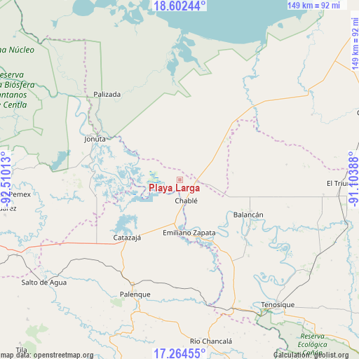
Playa Larga GPS coordinates[2]
17° 56' 5.136" North, 91° 48' 25.2" West
| Map corner | latitude | longitude |
|---|---|---|
| Upper-left | 18.60244°, | -92.51013° |
| Center: | 17.93476°, | -91.807° |
| Lower-right: | 17.26455°, | -91.10388° |
| Map W x H: | 148.8×148.8 km | = 92.5×92.5mi |
| max Lat: | 32.7° ⇑79.3% North |
| Playa Larga: | 17.93476° |
| min Lat: | ⇓20.7% South 14.53588° |
| min Long | Playa Larga | max Long |
| -117.105° | -91.807° | -86.73105° |
| W 95.8%⇐ | ⇒4.2% E |
Elevation
Elevation of Playa Larga is 6 m = 20 ft, and this is 1247.7 m = 4094 ft below average elevation for this country.
| Max E: |
3497 m = 11473 ft | 99.1% |
| Avg. | 1253.7 m = 4113 ft | |
| Playa Larga | 6 m = 20 ft | |
Min E: |
-1 m = -3 ft | 0.9% |
See also: Mexico elevation on elevation.city.
Geographical zone
Playa Larga is located in North Torrid zone (between Equator and Tropic of Cancer). Distance of this Northern Tropic circle is 611.8 km =380.2 mi to North.| Distance of | km | miles | from Playa Larga |
|---|---|---|---|
| North Pole | 8012.9 | 4979 | to North |
| Arctic Circle | 5407 | 3359.8 | to North |
| Tropic Cancer | 611.8 | 380.2 | to North |
| Equator | 1994.2 | 1239.1 | to South |


Nearby cities:
15 places around Playa Larga: (largest is in red/bold)
• Balancán
31.8 km =19.8 mi,  116°
116°
• Boca de San Jerónimo
11.7 km =7.3 mi,  253°
253°
• Calatraba
17.3 km =10.7 mi,  173°
173°
• Catazajá
32 km =19.9 mi,  222°
222°
• Chablé
8.9 km =5.5 mi,  162°
162°
• El Paraíso
29.6 km =18.4 mi,  237°
237°
• El Pípila
22.3 km =13.9 mi,  81°
81°
• Emiliano Zapata
22 km =13.7 mi, 168°
• Ignacio Zaragoza
25.5 km =15.8 mi,  229°
229°
• José María Morelos y Pavón Centro
28.2 km =17.5 mi,  181°
181°
• La Guayaba (Alto Amatitán)
4 km =2.5 mi,  197°
197°
• La Libertad
29 km =18 mi, 161°
• Los Pájaros
28.8 km =17.9 mi,  264°
264°
• Torno Largo 2da. Sección
23 km =14.3 mi,  265°
265°
• Vicente Guerrero
26 km =16.2 mi,  135°
135°
Sources, notices
• [Note1] Compared only with cities in Mexico existing in our database
• [Src1] Map data: © OpenStreetMap contributors (CC-BY-SA)
• [Src2] Other city data from geonames.org with taken over terms of usage.
• [Src3] Geographical zone / Annual Mean Temperature by Robert A. Rohde @ Wikipedia
