Bomanxotha geodata
Bomanxotha (Hidalgo) is a populated place; located in Mexico in America/Mexico_City (GMT-6) time zone. With population of 2,025 people, there are 4296 cities with bigger population in this country. Compared to other cities in Mexico, 68.1% of cities are located further ↓South; 59.7% of cities are located further →East and 62.7% of cities have lower elevation than Bomanxotha. Note1


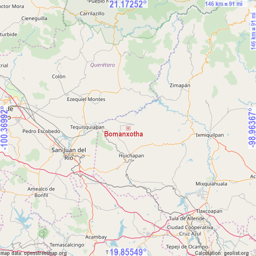
Bomanxotha GPS coordinates[2]
20° 30' 55.512" North, 99° 40' 0.444" West
| Map corner | latitude | longitude |
|---|---|---|
| Upper-left | 21.17252°, | -100.36992° |
| Center: | 20.51542°, | -99.66679° |
| Lower-right: | 19.85549°, | -98.96367° |
| Map W x H: | 146.4×146.4 km | = 91×91mi |
| max Lat: | 32.7° ⇑31.9% North |
| Bomanxotha: | 20.51542° |
| min Lat: | ⇓68.1% South 14.53588° |
| min Long | Bomanxotha | max Long |
| -117.105° | -99.66679° | -86.73105° |
| W 40.3%⇐ | ⇒59.7% E |
Elevation
Elevation of Bomanxotha is 1772 m = 5814 ft, and this is 518.3 m = 1700 ft above average elevation for this country.
| Max E: |
3497 m = 11473 ft | 37.3% |
| Bomanxotha | 1772 m 5814 ft | |
| Avg. | 1253.7 m = 4113 ft | |
Min E: |
-1 m = -3 ft | 62.7% |
See also: Mexico elevation on elevation.city.
Geographical zone
Bomanxotha is located in North Torrid zone (between Equator and Tropic of Cancer). Distance of this Northern Tropic circle is 324.8 km =201.8 mi to North.| Distance of | km | miles | from Bomanxotha |
|---|---|---|---|
| North Pole | 7726 | 4800.7 | to North |
| Arctic Circle | 5120.1 | 3181.5 | to North |
| Tropic Cancer | 324.8 | 201.8 | to North |
| Equator | 2281.1 | 1417.4 | to South |


Nearby cities:
15 places around Bomanxotha: (largest is in red/bold)
• Atengo
6.6 km =4.1 mi,  240°
240°
• Bondojito
8.7 km =5.4 mi,  203°
203°
• Boyecito
8.2 km =5.1 mi,  347°
347°
• El Riíto
7.8 km =4.8 mi,  29°
29°
• Gandhó
3.9 km =2.4 mi,  327°
327°
• La Esquina
5.5 km =3.4 mi,  309°
309°
• La Mesilla
3.1 km =1.9 mi, 199°
• Pañhé
3.2 km =2 mi,  282°
282°
• San Antonio
4.9 km =3 mi,  292°
292°
• San Francisco
8.3 km =5.2 mi, 236°
• San Miguel Caltepantla
6 km =3.7 mi,  128°
128°
• Taguí
8.3 km =5.2 mi,  160°
160°
• Tecozautla
3.9 km =2.4 mi,  59°
59°
• Tenzabhí
3.2 km =2 mi,  111°
111°
• Uxdejhé
7.3 km =4.5 mi,  0°
0°
Sources, notices
• [Note1] Compared only with cities in Mexico existing in our database
• [Src1] Map data: © OpenStreetMap contributors (CC-BY-SA)
• [Src2] Other city data from geonames.org with taken over terms of usage.
• [Src3] Geographical zone / Annual Mean Temperature by Robert A. Rohde @ Wikipedia
