La Esquina geodata
La Esquina (Hidalgo) is a populated place; located in Mexico in America/Mexico_City (GMT-6) time zone. With population of 1,520 people, there are 5670 cities with bigger population in this country. Compared to other cities in Mexico, 68.8% of cities are located further ↓South; 60.3% of cities are located further →East and 60.2% of cities have lower elevation than La Esquina. Note1


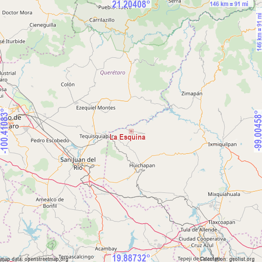
La Esquina GPS coordinates[2]
20° 32' 49.632" North, 99° 42' 27.72" West
| Map corner | latitude | longitude |
|---|---|---|
| Upper-left | 21.20408°, | -100.41083° |
| Center: | 20.54712°, | -99.7077° |
| Lower-right: | 19.88732°, | -99.00458° |
| Map W x H: | 146.4×146.4 km | = 91×91mi |
| max Lat: | 32.7° ⇑31.2% North |
| La Esquina: | 20.54712° |
| min Lat: | ⇓68.8% South 14.53588° |
| min Long | La Esquina | max Long |
| -117.105° | -99.7077° | -86.73105° |
| W 39.7%⇐ | ⇒60.3% E |
Elevation
Elevation of La Esquina is 1729 m = 5673 ft, and this is 475.3 m = 1559 ft above average elevation for this country.
| Max E: |
3497 m = 11473 ft | 39.8% |
| La Esquina | 1729 m 5673 ft | |
| Avg. | 1253.7 m = 4113 ft | |
Min E: |
-1 m = -3 ft | 60.2% |
See also: Mexico elevation on elevation.city.
Geographical zone
La Esquina is located in North Torrid zone (between Equator and Tropic of Cancer). Distance of this Northern Tropic circle is 321.3 km =199.6 mi to North.| Distance of | km | miles | from La Esquina |
|---|---|---|---|
| North Pole | 7722.4 | 4798.5 | to North |
| Arctic Circle | 5116.5 | 3179.2 | to North |
| Tropic Cancer | 321.3 | 199.6 | to North |
| Equator | 2284.6 | 1419.6 | to South |


Nearby cities:
15 places around La Esquina: (largest is in red/bold)
• Atengo
6.9 km =4.3 mi,  192°
192°
• Bomanxotha
5.5 km =3.4 mi,  129°
129°
• Boyecito
5.1 km =3.2 mi,  29°
29°
• El Riíto
8.7 km =5.4 mi,  67°
67°
• Gandhó
2.1 km =1.3 mi,  95°
95°
• La Mesilla
7.2 km =4.5 mi,  153°
153°
• Pathé
5.9 km =3.7 mi,  6°
6°
• Pañhé
3.1 km =1.9 mi,  157°
157°
• Portezuelo
6.3 km =3.9 mi,  328°
328°
• San Antonio
1.7 km =1.1 mi, 189°
• San Francisco
8.5 km =5.3 mi,  197°
197°
• San Joaquín
8.5 km =5.3 mi,  236°
236°
• Tecozautla
7.8 km =4.8 mi, 101°
• Tenzabhí
8.6 km =5.3 mi,  122°
122°
• Uxdejhé
5.7 km =3.5 mi,  48°
48°
Sources, notices
• [Note1] Compared only with cities in Mexico existing in our database
• [Src1] Map data: © OpenStreetMap contributors (CC-BY-SA)
• [Src2] Other city data from geonames.org with taken over terms of usage.
• [Src3] Geographical zone / Annual Mean Temperature by Robert A. Rohde @ Wikipedia
