La Mesilla geodata
La Mesilla (Hidalgo) is a populated place; located in Mexico in America/Mexico_City (GMT-6) time zone. With population of 1,573 people, there are 5492 cities with bigger population in this country. Compared to other cities in Mexico, 67.6% of cities are located further ↓South; 59.9% of cities are located further →East and 67.9% of cities have lower elevation than La Mesilla. Note1


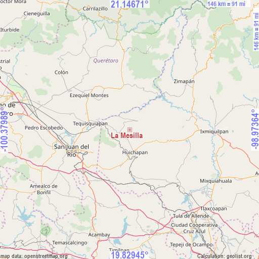
La Mesilla GPS coordinates[2]
20° 29' 22.164" North, 99° 40' 36.336" West
| Map corner | latitude | longitude |
|---|---|---|
| Upper-left | 21.14671°, | -100.37989° |
| Center: | 20.48949°, | -99.67676° |
| Lower-right: | 19.82945°, | -98.97364° |
| Map W x H: | 146.5×146.5 km | = 91×91mi |
| max Lat: | 32.7° ⇑32.4% North |
| La Mesilla: | 20.48949° |
| min Lat: | ⇓67.6% South 14.53588° |
| min Long | La Mesilla | max Long |
| -117.105° | -99.67676° | -86.73105° |
| W 40.1%⇐ | ⇒59.9% E |
Elevation
Elevation of La Mesilla is 1888 m = 6194 ft, and this is 634.3 m = 2081 ft above average elevation for this country.
| Max E: |
3497 m = 11473 ft | 32.1% |
| La Mesilla | 1888 m 6194 ft | |
| Avg. | 1253.7 m = 4113 ft | |
Min E: |
-1 m = -3 ft | 67.9% |
See also: Mexico elevation on elevation.city.
Geographical zone
La Mesilla is located in North Torrid zone (between Equator and Tropic of Cancer). Distance of this Northern Tropic circle is 327.7 km =203.6 mi to North.| Distance of | km | miles | from La Mesilla |
|---|---|---|---|
| North Pole | 7728.8 | 4802.5 | to North |
| Arctic Circle | 5123 | 3183.3 | to North |
| Tropic Cancer | 327.7 | 203.6 | to North |
| Equator | 2278.2 | 1415.6 | to South |


Nearby cities:
15 places around La Mesilla: (largest is in red/bold)
• Atengo
4.7 km =2.9 mi,  265°
265°
• Bomanxotha
3.1 km =1.9 mi,  19°
19°
• Bondojito
5.6 km =3.5 mi,  205°
205°
• Gandhó
6.3 km =3.9 mi,  349°
349°
• La Esquina
7.2 km =4.5 mi,  333°
333°
• Mamithi
9 km =5.6 mi,  167°
167°
• Maxtha
8.7 km =5.4 mi,  120°
120°
• Pañhé
4.1 km =2.5 mi, 329°
• San Antonio
5.9 km =3.7 mi,  323°
323°
• San Francisco
6.1 km =3.8 mi,  253°
253°
• San Miguel Caltepantla
5.8 km =3.6 mi,  98°
98°
• Taguí
6.2 km =3.9 mi,  142°
142°
• Tecozautla
6.6 km =4.1 mi,  41°
41°
• Tenzabhí
4.4 km =2.7 mi,  66°
66°
• Uxdejhé
10.2 km =6.3 mi,  5°
5°
Sources, notices
• [Note1] Compared only with cities in Mexico existing in our database
• [Src1] Map data: © OpenStreetMap contributors (CC-BY-SA)
• [Src2] Other city data from geonames.org with taken over terms of usage.
• [Src3] Geographical zone / Annual Mean Temperature by Robert A. Rohde @ Wikipedia
