Uxdejhé geodata
Uxdejhé (Hidalgo) is a populated place; located in Mexico in America/Mexico_City (GMT-6) time zone. With population of 794 people, there are 10982 cities with bigger population in this country. Compared to other cities in Mexico, 69.6% of cities are located further ↓South; 59.7% of cities are located further →East and 61.8% of cities have lower elevation than Uxdejhé. Note1


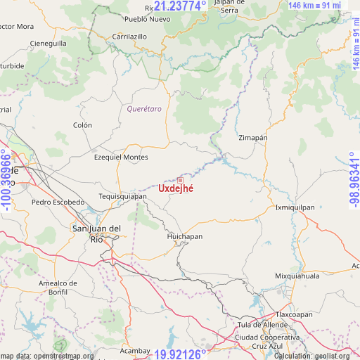
Uxdejhé GPS coordinates[2]
20° 34' 51.312" North, 99° 39' 59.508" West
| Map corner | latitude | longitude |
|---|---|---|
| Upper-left | 21.23774°, | -100.36966° |
| Center: | 20.58092°, | -99.66653° |
| Lower-right: | 19.92126°, | -98.96341° |
| Map W x H: | 146.4×146.4 km | = 91×91mi |
| max Lat: | 32.7° ⇑30.4% North |
| Uxdejhé: | 20.58092° |
| min Lat: | ⇓69.6% South 14.53588° |
| min Long | Uxdejhé | max Long |
| -117.105° | -99.66653° | -86.73105° |
| W 40.3%⇐ | ⇒59.7% E |
Elevation
Elevation of Uxdejhé is 1755 m = 5758 ft, and this is 501.3 m = 1645 ft above average elevation for this country.
| Max E: |
3497 m = 11473 ft | 38.2% |
| Uxdejhé | 1755 m 5758 ft | |
| Avg. | 1253.7 m = 4113 ft | |
Min E: |
-1 m = -3 ft | 61.8% |
See also: Mexico elevation on elevation.city.
Geographical zone
Uxdejhé is located in North Torrid zone (between Equator and Tropic of Cancer). Distance of this Northern Tropic circle is 317.5 km =197.3 mi to North.| Distance of | km | miles | from Uxdejhé |
|---|---|---|---|
| North Pole | 7718.7 | 4796.2 | to North |
| Arctic Circle | 5112.8 | 3176.9 | to North |
| Tropic Cancer | 317.5 | 197.3 | to North |
| Equator | 2288.4 | 1421.9 | to South |


Nearby cities:
15 places around Uxdejhé: (largest is in red/bold)
• Atengo
12 km =7.5 mi,  208°
208°
• Banzha
8.3 km =5.2 mi,  84°
84°
• Bomanxotha
7.3 km =4.5 mi,  180°
180°
• Boyecito
1.9 km =1.2 mi,  292°
292°
• El Riíto
3.8 km =2.4 mi,  96°
96°
• Gandhó
4.5 km =2.8 mi, 208°
• La Esquina
5.7 km =3.5 mi,  228°
228°
• La Mesilla
10.2 km =6.3 mi,  185°
185°
• Pathé
4.2 km =2.6 mi,  300°
300°
• Pañhé
7.3 km =4.5 mi, 205°
• Portezuelo
7.7 km =4.8 mi,  281°
281°
• San Antonio
7.1 km =4.4 mi,  220°
220°
• San Miguel Caltepantla
12 km =7.5 mi,  157°
157°
• Tecozautla
6.2 km =3.9 mi,  147°
147°
• Tenzabhí
8.9 km =5.5 mi, 160°
Sources, notices
• [Note1] Compared only with cities in Mexico existing in our database
• [Src1] Map data: © OpenStreetMap contributors (CC-BY-SA)
• [Src2] Other city data from geonames.org with taken over terms of usage.
• [Src3] Geographical zone / Annual Mean Temperature by Robert A. Rohde @ Wikipedia
