Tenzabhí geodata
Tenzabhí (Hidalgo) is a populated place; located in Mexico in America/Mexico_City (GMT-6) time zone. With population of 582 people, there are 14734 cities with bigger population in this country. Compared to other cities in Mexico, 67.9% of cities are located further ↓South; 59.2% of cities are located further →East and 64% of cities have lower elevation than Tenzabhí. Note1


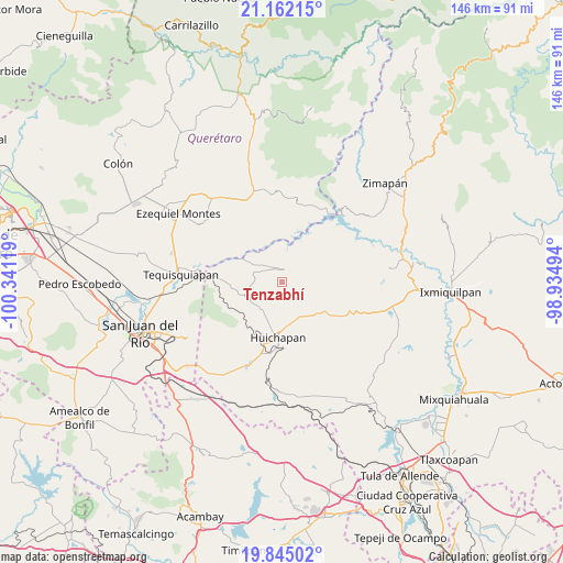
Tenzabhí GPS coordinates[2]
20° 30' 18" North, 99° 38' 17.016" West
| Map corner | latitude | longitude |
|---|---|---|
| Upper-left | 21.16215°, | -100.34119° |
| Center: | 20.505°, | -99.63806° |
| Lower-right: | 19.84502°, | -98.93494° |
| Map W x H: | 146.5×146.5 km | = 91×91mi |
| max Lat: | 32.7° ⇑32.1% North |
| Tenzabhí: | 20.505° |
| min Lat: | ⇓67.9% South 14.53588° |
| min Long | Tenzabhí | max Long |
| -117.105° | -99.63806° | -86.73105° |
| W 40.8%⇐ | ⇒59.2% E |
Elevation
Elevation of Tenzabhí is 1800 m = 5906 ft, and this is 546.3 m = 1792 ft above average elevation for this country.
| Max E: |
3497 m = 11473 ft | 36% |
| Tenzabhí | 1800 m 5906 ft | |
| Avg. | 1253.7 m = 4113 ft | |
Min E: |
-1 m = -3 ft | 64% |
See also: Mexico elevation on elevation.city.
Geographical zone
Tenzabhí is located in North Torrid zone (between Equator and Tropic of Cancer). Distance of this Northern Tropic circle is 326 km =202.6 mi to North.| Distance of | km | miles | from Tenzabhí |
|---|---|---|---|
| North Pole | 7727.1 | 4801.4 | to North |
| Arctic Circle | 5121.2 | 3182.2 | to North |
| Tropic Cancer | 326 | 202.6 | to North |
| Equator | 2279.9 | 1416.7 | to South |


Nearby cities:
15 places around Tenzabhí: (largest is in red/bold)
• Apartadero
8.6 km =5.3 mi,  92°
92°
• Atengo
9 km =5.6 mi,  256°
256°
• Bomanxotha
3.2 km =2 mi,  291°
291°
• Dantzibojay
9.1 km =5.7 mi,  143°
143°
• El Riíto
8 km =5 mi,  5°
5°
• Gandhó
6.8 km =4.2 mi,  311°
311°
• La Esquina
8.6 km =5.3 mi,  302°
302°
• La Mesilla
4.4 km =2.7 mi,  246°
246°
• Maxtha
7.1 km =4.4 mi,  150°
150°
• Pañhé
6.4 km =4 mi, 286°
• San Antonio
8.1 km =5 mi, 291°
• San Miguel Caltepantla
3.1 km =1.9 mi, 147°
• Taguí
6.6 km =4.1 mi,  181°
181°
• Tecozautla
3.2 km =2 mi, 6°
• Uxdejhé
8.9 km =5.5 mi,  340°
340°
Sources, notices
• [Note1] Compared only with cities in Mexico existing in our database
• [Src1] Map data: © OpenStreetMap contributors (CC-BY-SA)
• [Src2] Other city data from geonames.org with taken over terms of usage.
• [Src3] Geographical zone / Annual Mean Temperature by Robert A. Rohde @ Wikipedia
