Álvaro Obregón geodata
Álvaro Obregón (Hidalgo) is a populated place; located in Mexico in America/Mexico_City (GMT-6) time zone. With population of 1,032 people, there are 8443 cities with bigger population in this country. Compared to other cities in Mexico, 71.8% of cities are located further ↓South; 55.3% of cities are located further →East and 61.4% of cities have lower elevation than Álvaro Obregón. Note1


Álvaro Obregón GPS coordinates[2]
20° 42' 23.832" North, 99° 22' 23.628" West
| Map corner | latitude | longitude |
|---|---|---|
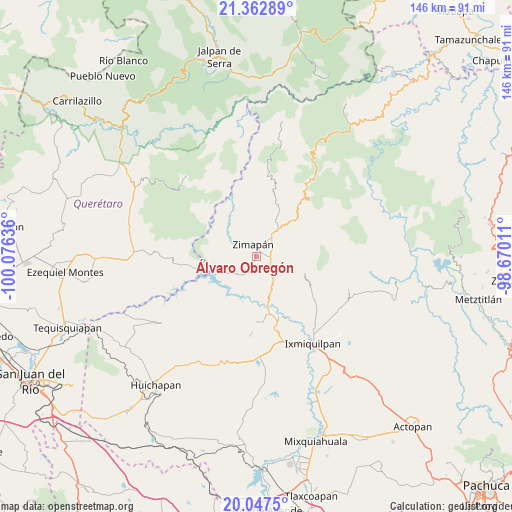
| Upper-left | 21.36289°, | -100.07636° |
| Center: | 20.70662°, | -99.37323° |
| Lower-right: | 20.0475°, | -98.67011° |
| Map W x H: | 146.3×146.3 km | = 90.9×90.9mi |
| max Lat: | 32.7° ⇑28.2% North |
| Álvaro Obregón: | 20.70662° |
| min Lat: | ⇓71.8% South 14.53588° |
| min Long | Álvaro Obregó | max Long |
| -117.105° | -99.37323° | -86.73105° |
| W 44.7%⇐ | ⇒55.3% E |
Elevation
Elevation of Álvaro Obregón is 1749 m = 5738 ft, and this is 495.3 m = 1625 ft above average elevation for this country.
| Max E: |
3497 m = 11473 ft | 38.6% |
| Álvaro Obregón | 1749 m 5738 ft | |
| Avg. | 1253.7 m = 4113 ft | |
Min E: |
-1 m = -3 ft | 61.4% |
See also: Mexico elevation on elevation.city.
Geographical zone
Álvaro Obregón is located in North Torrid zone (between Equator and Tropic of Cancer). Distance of this Northern Tropic circle is 303.6 km =188.6 mi to North.| Distance of | km | miles | from Álvaro Obregón |
|---|---|---|---|
| North Pole | 7704.7 | 4787.5 | to North |
| Arctic Circle | 5098.8 | 3168.2 | to North |
| Tropic Cancer | 303.6 | 188.6 | to North |
| Equator | 2302.4 | 1430.6 | to South |


Nearby cities:
15 places around Álvaro Obregón: (largest is in red/bold)
• Arbolado
16.8 km =10.4 mi,  162°
162°
• Benito Juárez
5.7 km =3.5 mi,  335°
335°
• Caltimacan
18.9 km =11.7 mi,  178°
178°
• El Salitre
4.4 km =2.7 mi,  78°
78°
• El Tule
3.6 km =2.2 mi,  25°
25°
• Francisco I. Madero
6.3 km =3.9 mi,  63°
63°
• La Candelaria
17.1 km =10.6 mi, 156°
• La Lagunita
14.8 km =9.2 mi,  111°
111°
• Llano Blanco
2.3 km =1.4 mi,  66°
66°
• Lázaro Cárdenas
4.8 km =3 mi,  96°
96°
• San Isidro
18.6 km =11.6 mi, 163°
• San Pedro
18.5 km =11.5 mi,  234°
234°
• Tasquillo
18.7 km =11.6 mi, 160°
• Tlalpan
1.8 km =1.1 mi,  46°
46°
• Zimapan
3.6 km =2.2 mi,  345°
345°
Sources, notices
• [Note1] Compared only with cities in Mexico existing in our database
• [Src1] Map data: © OpenStreetMap contributors (CC-BY-SA)
• [Src2] Other city data from geonames.org with taken over terms of usage.
• [Src3] Geographical zone / Annual Mean Temperature by Robert A. Rohde @ Wikipedia
