Xochitlán geodata
Xochitlán (Hidalgo) is a populated place; located in Mexico in America/Mexico_City (GMT-6) time zone. With population of 1,869 people, there are 4645 cities with bigger population in this country. Compared to other cities in Mexico, 63.4% of cities are located further ↓South; 52.5% of cities are located further →East and 73.4% of cities have lower elevation than Xochitlán. Note1


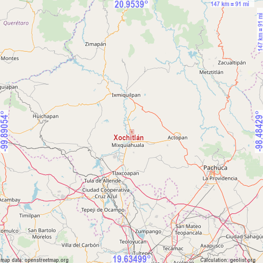
Xochitlán GPS coordinates[2]
20° 17' 45.06" North, 99° 11' 14.676" West
| Map corner | latitude | longitude |
|---|---|---|
| Upper-left | 20.9539°, | -99.89054° |
| Center: | 20.29585°, | -99.18741° |
| Lower-right: | 19.63499°, | -98.48429° |
| Map W x H: | 146.6×146.7 km | = 91.1×91.2mi |
| max Lat: | 32.7° ⇑36.6% North |
| Xochitlán: | 20.29585° |
| min Lat: | ⇓63.4% South 14.53588° |
| min Long | Xochitlán | max Long |
| -117.105° | -99.18741° | -86.73105° |
| W 47.5%⇐ | ⇒52.5% E |
Elevation
Elevation of Xochitlán is 1999 m = 6558 ft, and this is 745.3 m = 2445 ft above average elevation for this country.
| Max E: |
3497 m = 11473 ft | 26.6% |
| Xochitlán | 1999 m 6558 ft | |
| Avg. | 1253.7 m = 4113 ft | |
Min E: |
-1 m = -3 ft | 73.4% |
See also: Mexico elevation on elevation.city.
Geographical zone
Xochitlán is located in North Torrid zone (between Equator and Tropic of Cancer). Distance of this Northern Tropic circle is 349.2 km =217 mi to North.| Distance of | km | miles | from Xochitlán |
|---|---|---|---|
| North Pole | 7750.4 | 4815.9 | to North |
| Arctic Circle | 5144.5 | 3196.6 | to North |
| Tropic Cancer | 349.2 | 217 | to North |
| Equator | 2256.7 | 1402.2 | to South |


Nearby cities:
15 places around Xochitlán: (largest is in red/bold)
• Arbol Grande
9.1 km =5.7 mi,  171°
171°
• Chilcuautla
6 km =3.7 mi,  310°
310°
• Colonia Benito Juárez
4.8 km =3 mi,  87°
87°
• Colonia Morelos (El Nueve)
9.2 km =5.7 mi,  148°
148°
• Dengantzha
7.4 km =4.6 mi,  110°
110°
• El Dontzhí (Colonia Álamos)
7 km =4.3 mi, 312°
• El Moreno (San Miguel Moreno)
1.6 km =1 mi,  66°
66°
• Jagüey Blanco
4.3 km =2.7 mi,  120°
120°
• La Puerta
8.8 km =5.5 mi, 122°
• Mixquiahuala de Juarez
7.8 km =4.8 mi,  200°
200°
• Palmillas
8.7 km =5.4 mi,  187°
187°
• Progreso de Alvaro Obregon
5.2 km =3.2 mi,  182°
182°
• Santa Ana Batha
9.3 km =5.8 mi,  357°
357°
• Texcatepec
7.2 km =4.5 mi,  252°
252°
• Tunititlán
7.9 km =4.9 mi,  228°
228°
Sources, notices
• [Note1] Compared only with cities in Mexico existing in our database
• [Src1] Map data: © OpenStreetMap contributors (CC-BY-SA)
• [Src2] Other city data from geonames.org with taken over terms of usage.
• [Src3] Geographical zone / Annual Mean Temperature by Robert A. Rohde @ Wikipedia
