Lomas del Pedregal geodata
Lomas del Pedregal (Hidalgo) is a populated place; located in Mexico in America/Mexico_City (GMT-6) time zone. With population of 990 people, there are 8795 cities with bigger population in this country. Compared to other cities in Mexico, 51.4% of cities are located further ↓South; 57.3% of cities are located further ←West and 93.6% of cities have lower elevation than Lomas del Pedregal. Note1


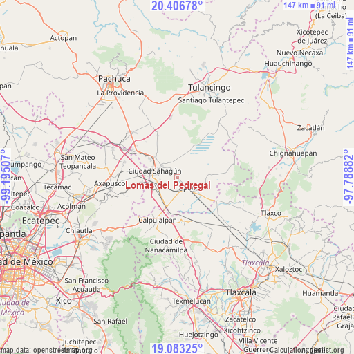
Lomas del Pedregal GPS coordinates[2]
19° 44' 47.004" North, 98° 29' 30.984" West
| Map corner | latitude | longitude |
|---|---|---|
| Upper-left | 20.40678°, | -99.19507° |
| Center: | 19.74639°, | -98.49194° |
| Lower-right: | 19.08325°, | -97.78882° |
| Map W x H: | 147.2×147.2 km | = 91.5×91.5mi |
| max Lat: | 32.7° ⇑48.6% North |
| Lomas del Pedregal: | 19.74639° |
| min Lat: | ⇓51.4% South 14.53588° |
| min Long | Lomas del Pedre | max Long |
| -117.105° | -98.49194° | -86.73105° |
| W 57.3%⇐ | ⇒42.7% E |
Elevation
Elevation of Lomas del Pedregal is 2553 m = 8376 ft, and this is 1299.3 m = 4263 ft above average elevation for this country.
| Max E: |
3497 m = 11473 ft | 6.4% |
| Lomas del Pedregal | 2553 m 8376 ft | |
| Avg. | 1253.7 m = 4113 ft | |
Min E: |
-1 m = -3 ft | 93.6% |
See also: Mexico elevation on elevation.city.
Geographical zone
Lomas del Pedregal is located in North Torrid zone (between Equator and Tropic of Cancer). Distance of this Northern Tropic circle is 410.3 km =254.9 mi to North.| Distance of | km | miles | from Lomas del Pedregal |
|---|---|---|---|
| North Pole | 7811.5 | 4853.8 | to North |
| Arctic Circle | 5205.6 | 3234.6 | to North |
| Tropic Cancer | 410.3 | 254.9 | to North |
| Equator | 2195.6 | 1364.3 | to South |


Nearby cities:
15 places around Lomas del Pedregal: (largest is in red/bold)
• Acopinalco
5.9 km =3.7 mi,  226°
226°
• Almoloya
10.3 km =6.4 mi,  116°
116°
• Apan
5.8 km =3.6 mi,  132°
132°
• Chimalpa y Tlalayote
9.3 km =5.8 mi,  193°
193°
• Ciudad Sahagun
9.2 km =5.7 mi,  290°
290°
• Colonia 20 de Noviembre
2.9 km =1.8 mi,  329°
329°
• Irolo
11 km =6.8 mi,  263°
263°
• La Laguna
1.6 km =1 mi,  212°
212°
• Los Cides
7 km =4.3 mi,  336°
336°
• Los Voladores
7.2 km =4.5 mi,  182°
182°
• Ocotepec
8.3 km =5.2 mi, 132°
• San Bartolomé Tepetates
7 km =4.3 mi, 264°
• San Juan Ixtilmaco
10 km =6.2 mi,  153°
153°
• Santa Clara
10.4 km =6.5 mi,  239°
239°
• Tepeapulco
7.9 km =4.9 mi,  306°
306°
Sources, notices
• [Note1] Compared only with cities in Mexico existing in our database
• [Src1] Map data: © OpenStreetMap contributors (CC-BY-SA)
• [Src2] Other city data from geonames.org with taken over terms of usage.
• [Src3] Geographical zone / Annual Mean Temperature by Robert A. Rohde @ Wikipedia
