Acopinalco del Peñón geodata
Acopinalco del Peñón (Tlaxcala) is a populated place; located in Mexico in America/Mexico_City (GMT-6) time zone. With population of 2,382 people, there are 3703 cities with bigger population in this country. Compared to other cities in Mexico, 50.7% of cities are located further ↑North; 61.8% of cities are located further ←West and 96.5% of cities have lower elevation than Acopinalco del Peñón. Note1
Current local time in Acopinalco del Peñón:
05:30 AM, WednesdayDifference from your time zone: hours


Acopinalco del Peñón GPS coordinates[2]
19° 39' 33.444" North, 98° 9' 46.764" West
| Map corner | latitude | longitude |
|---|---|---|
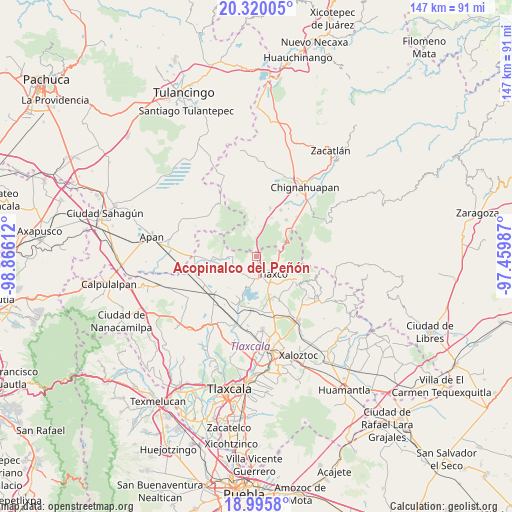
| Upper-left | 20.32005°, | -98.86612° |
| Center: | 19.65929°, | -98.16299° |
| Lower-right: | 18.9958°, | -97.45987° |
| Map W x H: | 147.2×147.2 km | = 91.5×91.5mi |
| max Lat: | 32.7° ⇑50.7% North |
| Acopinalco del Peñón: | 19.65929° |
| min Lat: | ⇓49.3% South 14.53588° |
| min Long | Acopinalco del | max Long |
| -117.105° | -98.16299° | -86.73105° |
| W 61.8%⇐ | ⇒38.2% E |
Elevation
Elevation of Acopinalco del Peñón is 2650 m = 8694 ft, and this is 1396.3 m = 4581 ft above average elevation for this country.
| Max E: |
3497 m = 11473 ft | 3.5% |
| Acopinalco del Peñón | 2650 m 8694 ft | |
| Avg. | 1253.7 m = 4113 ft | |
Min E: |
-1 m = -3 ft | 96.5% |
See also: Mexico elevation on elevation.city.
Geographical zone
Acopinalco del Peñón is located in North Torrid zone (between Equator and Tropic of Cancer). Distance of this Northern Tropic circle is 420 km =261 mi to North.| Distance of | km | miles | from Acopinalco del Peñón |
|---|---|---|---|
| North Pole | 7821.2 | 4859.9 | to North |
| Arctic Circle | 5215.3 | 3240.6 | to North |
| Tropic Cancer | 420 | 261 | to North |
| Equator | 2185.9 | 1358.3 | to South |


Nearby cities:
15 places around Acopinalco del Peñón: (largest is in red/bold)
• Acolihuia
14.4 km =8.9 mi,  15°
15°
• Casa Blanca
8.2 km =5.1 mi,  272°
272°
• El Fresno
11.9 km =7.4 mi,  48°
48°
• El Rosario
6.9 km =4.3 mi, 271°
• Lagunilla
11.9 km =7.4 mi,  257°
257°
• Llano Verde
11.9 km =7.4 mi, 20°
• Los Ranchos (Rinconada)
7.6 km =4.7 mi,  334°
334°
• Mariano Matamoros
12 km =7.5 mi, 268°
• Rinconada
6.6 km =4.1 mi,  336°
336°
• San Antonio Matlahuacales
13.6 km =8.5 mi,  38°
38°
• San José Tepeyahualco
12.9 km =8 mi,  239°
239°
• Tecomaluca
12.3 km =7.6 mi,  121°
121°
• Tlaxco
6.7 km =4.2 mi,  137°
137°
• Villa Cuauhtémoc
14.9 km =9.3 mi,  27°
27°
• Zumpango
13 km =8.1 mi,  209°
209°
Sources, notices
• [Note1] Compared only with cities in Mexico existing in our database
• [Src1] Map data: © OpenStreetMap contributors (CC-BY-SA)
• [Src2] Other city data from geonames.org with taken over terms of usage.
• [Src3] Geographical zone / Annual Mean Temperature by Robert A. Rohde @ Wikipedia
