Rancho Nuevo geodata
Rancho Nuevo (Hidalgo) is a populated place; located in Mexico in America/Mexico_City (GMT-6) time zone. With population of 761 people, there are 11509 cities with bigger population in this country. Compared to other cities in Mexico, 51.5% of cities are located further ↓South; 60.2% of cities are located further ←West and 98.5% of cities have lower elevation than Rancho Nuevo. Note1


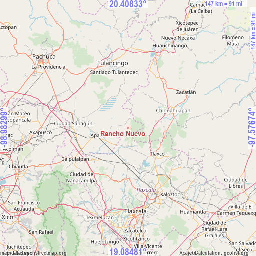
Rancho Nuevo GPS coordinates[2]
19° 44' 52.584" North, 98° 16' 47.496" West
| Map corner | latitude | longitude |
|---|---|---|
| Upper-left | 20.40833°, | -98.98299° |
| Center: | 19.74794°, | -98.27986° |
| Lower-right: | 19.08481°, | -97.57674° |
| Map W x H: | 147.2×147.2 km | = 91.5×91.5mi |
| max Lat: | 32.7° ⇑48.5% North |
| Rancho Nuevo: | 19.74794° |
| min Lat: | ⇓51.5% South 14.53588° |
| min Long | Rancho Nuevo | max Long |
| -117.105° | -98.27986° | -86.73105° |
| W 60.2%⇐ | ⇒39.8% E |
Elevation
Elevation of Rancho Nuevo is 2789 m = 9150 ft, and this is 1535.3 m = 5037 ft above average elevation for this country.
| Max E: |
3497 m = 11473 ft | 1.5% |
| Rancho Nuevo | 2789 m 9150 ft | |
| Avg. | 1253.7 m = 4113 ft | |
Min E: |
-1 m = -3 ft | 98.5% |
See also: Mexico elevation on elevation.city.
Geographical zone
Rancho Nuevo is located in North Torrid zone (between Equator and Tropic of Cancer). Distance of this Northern Tropic circle is 410.2 km =254.9 mi to North.| Distance of | km | miles | from Rancho Nuevo |
|---|---|---|---|
| North Pole | 7811.3 | 4853.7 | to North |
| Arctic Circle | 5205.4 | 3234.5 | to North |
| Tropic Cancer | 410.2 | 254.9 | to North |
| Equator | 2195.8 | 1364.4 | to South |


Nearby cities:
15 places around Rancho Nuevo: (largest is in red/bold)
• Acopinalco del Peñón
15.7 km =9.8 mi,  128°
128°
• Almoloya
13.8 km =8.6 mi,  249°
249°
• Casa Blanca
10.3 km =6.4 mi,  156°
156°
• El Paredón
13.5 km =8.4 mi,  12°
12°
• El Rosario
11 km =6.8 mi,  151°
151°
• Lagunilla
12.5 km =7.8 mi,  177°
177°
• Los Ranchos (Rinconada)
9.4 km =5.8 mi,  108°
108°
• Mariano Matamoros
10.2 km =6.3 mi, 178°
• Ocotepec de Morelos
13.4 km =8.3 mi,  231°
231°
• Rinconada
10.3 km =6.4 mi, 111°
• San Lorenzo Sóltepec
16.4 km =10.2 mi,  192°
192°
• Santiago Tetlapayac
8.4 km =5.2 mi,  221°
221°
• Tepepatlaxco
9.6 km =6 mi,  273°
273°
• Tres Cabezas
14.8 km =9.2 mi,  1°
1°
• Unión Ejidal Tierra y Libertad
11.7 km =7.3 mi,  210°
210°
Sources, notices
• [Note1] Compared only with cities in Mexico existing in our database
• [Src1] Map data: © OpenStreetMap contributors (CC-BY-SA)
• [Src2] Other city data from geonames.org with taken over terms of usage.
• [Src3] Geographical zone / Annual Mean Temperature by Robert A. Rohde @ Wikipedia
