Plan de Ayala geodata
Plan de Ayala (Tlaxcala) is a populated place; located in Mexico in America/Mexico_City (GMT-6) time zone. With population of 501 people, there are 16785 cities with bigger population in this country. Compared to other cities in Mexico, 58.6% of cities are located further ↑North; 66.8% of cities are located further ←West and 91.1% of cities have lower elevation than Plan de Ayala. Note1


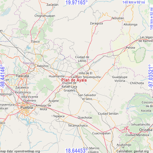
Plan de Ayala GPS coordinates[2]
19° 18' 33.984" North, 97° 44' 17.988" West
| Map corner | latitude | longitude |
|---|---|---|
| Upper-left | 19.97165°, | -98.44146° |
| Center: | 19.30944°, | -97.73833° |
| Lower-right: | 18.64453°, | -97.03521° |
| Map W x H: | 147.6×147.6 km | = 91.7×91.7mi |
| max Lat: | 32.7° ⇑58.6% North |
| Plan de Ayala: | 19.30944° |
| min Lat: | ⇓41.4% South 14.53588° |
| min Long | Plan de Ayala | max Long |
| -117.105° | -97.73833° | -86.73105° |
| W 66.8%⇐ | ⇒33.2% E |
Elevation
Elevation of Plan de Ayala is 2444 m = 8018 ft, and this is 1190.3 m = 3905 ft above average elevation for this country.
| Max E: |
3497 m = 11473 ft | 8.9% |
| Plan de Ayala | 2444 m 8018 ft | |
| Avg. | 1253.7 m = 4113 ft | |
Min E: |
-1 m = -3 ft | 91.1% |
See also: Mexico elevation on elevation.city.
Geographical zone
Plan de Ayala is located in North Torrid zone (between Equator and Tropic of Cancer). Distance of this Northern Tropic circle is 458.9 km =285.1 mi to North.| Distance of | km | miles | from Plan de Ayala |
|---|---|---|---|
| North Pole | 7860.1 | 4884 | to North |
| Arctic Circle | 5254.2 | 3264.8 | to North |
| Tropic Cancer | 458.9 | 285.1 | to North |
| Equator | 2147 | 1334.1 | to South |


Nearby cities:
15 places around Plan de Ayala: (largest is in red/bold)
• Colonia Ignacio Allende
7.1 km =4.4 mi,  317°
317°
• Colonia José María Morelos
7.1 km =4.4 mi,  35°
35°
• Colonia Obrera
10.8 km =6.7 mi,  214°
214°
• Cuapiaxtla
3.5 km =2.2 mi,  244°
244°
• La Soledad
7.5 km =4.7 mi, 42°
• Máximo Serdán
10.8 km =6.7 mi, 241°
• Nuevo Vicencio
6.1 km =3.8 mi,  113°
113°
• Ranchería de Pocitos
9.6 km =6 mi,  346°
346°
• San Francisco Cuexcontzi
3.1 km =1.9 mi,  67°
67°
• San José Chiapa
8.2 km =5.1 mi,  201°
201°
• San José Ozumba
8.6 km =5.3 mi,  172°
172°
• Santa Cruz Pocitos
8.1 km =5 mi,  342°
342°
• Santa María las Cuevas
8.5 km =5.3 mi,  359°
359°
• Unidad Grajales INFONAVIT
10.7 km =6.6 mi,  225°
225°
• Villa de El Carmen Tequexquitla
9.1 km =5.7 mi,  79°
79°
Sources, notices
• [Note1] Compared only with cities in Mexico existing in our database
• [Src1] Map data: © OpenStreetMap contributors (CC-BY-SA)
• [Src2] Other city data from geonames.org with taken over terms of usage.
• [Src3] Geographical zone / Annual Mean Temperature by Robert A. Rohde @ Wikipedia
