Ignacio Zaragoza geodata
Ignacio Zaragoza (Tlaxcala) is a populated place; located in Mexico in America/Mexico_City (GMT-6) time zone. With population of 6,916 people, there are 1346 cities with bigger population in this country. Compared to other cities in Mexico, 59% of cities are located further ↑North; 64.6% of cities are located further ←West and 93% of cities have lower elevation than Ignacio Zaragoza. Note1


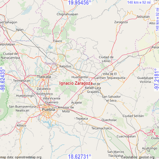
Ignacio Zaragoza GPS coordinates[2]
19° 17' 32.208" North, 97° 55' 16.392" West
| Map corner | latitude | longitude |
|---|---|---|
| Upper-left | 19.95456°, | -98.62435° |
| Center: | 19.29228°, | -97.92122° |
| Lower-right: | 18.62731°, | -97.2181° |
| Map W x H: | 147.6×147.6 km | = 91.7×91.7mi |
| max Lat: | 32.7° ⇑59% North |
| Ignacio Zaragoza: | 19.29228° |
| min Lat: | ⇓41% South 14.53588° |
| min Long | Ignacio Zaragoz | max Long |
| -117.105° | -97.92122° | -86.73105° |
| W 64.6%⇐ | ⇒35.4% E |
Elevation
Elevation of Ignacio Zaragoza is 2531 m = 8304 ft, and this is 1277.3 m = 4191 ft above average elevation for this country.
| Max E: |
3497 m = 11473 ft | 7% |
| Ignacio Zaragoza | 2531 m 8304 ft | |
| Avg. | 1253.7 m = 4113 ft | |
Min E: |
-1 m = -3 ft | 93% |
See also: Mexico elevation on elevation.city.
Geographical zone
Ignacio Zaragoza is located in North Torrid zone (between Equator and Tropic of Cancer). Distance of this Northern Tropic circle is 460.8 km =286.3 mi to North.| Distance of | km | miles | from Ignacio Zaragoza |
|---|---|---|---|
| North Pole | 7862 | 4885.2 | to North |
| Arctic Circle | 5256.1 | 3266 | to North |
| Tropic Cancer | 460.8 | 286.3 | to North |
| Equator | 2145.1 | 1332.9 | to South |


Nearby cities:
15 places around Ignacio Zaragoza: (largest is in red/bold)
• Benito Juárez
9.2 km =5.7 mi,  8°
8°
• Colonia Cuauhtémoc
6.3 km =3.9 mi,  313°
313°
• Colonia el Valle
9.2 km =5.7 mi,  36°
36°
• El Carmen Xalpatlahuaya
12.8 km =8 mi,  330°
330°
• Huamantla
2.5 km =1.6 mi,  350°
350°
• Ixtenco
5.4 km =3.4 mi,  147°
147°
• José María Morelos
6.6 km =4.1 mi,  295°
295°
• Los Pilares
3.6 km =2.2 mi,  229°
229°
• Lázaro Cárdenas
10.2 km =6.3 mi,  316°
316°
• Máximo Serdán
10.3 km =6.4 mi,  108°
108°
• Nopalucán
13.2 km =8.2 mi,  128°
128°
• San José Xicohténcatl
11.7 km =7.3 mi,  53°
53°
• San Juan Bautista Mier
8.8 km =5.5 mi,  135°
135°
• Unidad Grajales INFONAVIT
12.9 km =8 mi,  116°
116°
• Zitlaltépec
9.9 km =6.2 mi,  171°
171°
Sources, notices
• [Note1] Compared only with cities in Mexico existing in our database
• [Src1] Map data: © OpenStreetMap contributors (CC-BY-SA)
• [Src2] Other city data from geonames.org with taken over terms of usage.
• [Src3] Geographical zone / Annual Mean Temperature by Robert A. Rohde @ Wikipedia
