Los Pilares geodata
Los Pilares (Tlaxcala) is a populated place; located in Mexico in America/Mexico_City (GMT-6) time zone. With population of 1,280 people, there are 6771 cities with bigger population in this country. Compared to other cities in Mexico, 59.4% of cities are located further ↑North; 64.3% of cities are located further ←West and 97.2% of cities have lower elevation than Los Pilares. Note1


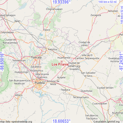
Los Pilares GPS coordinates[2]
19° 16' 17.724" North, 97° 56' 49.308" West
| Map corner | latitude | longitude |
|---|---|---|
| Upper-left | 19.93396°, | -98.65016° |
| Center: | 19.27159°, | -97.94703° |
| Lower-right: | 18.60653°, | -97.24391° |
| Map W x H: | 147.6×147.6 km | = 91.7×91.7mi |
| max Lat: | 32.7° ⇑59.4% North |
| Los Pilares: | 19.27159° |
| min Lat: | ⇓40.6% South 14.53588° |
| min Long | Los Pilares | max Long |
| -117.105° | -97.94703° | -86.73105° |
| W 64.3%⇐ | ⇒35.7% E |
Elevation
Elevation of Los Pilares is 2691 m = 8829 ft, and this is 1437.3 m = 4716 ft above average elevation for this country.
| Max E: |
3497 m = 11473 ft | 2.8% |
| Los Pilares | 2691 m 8829 ft | |
| Avg. | 1253.7 m = 4113 ft | |
Min E: |
-1 m = -3 ft | 97.2% |
See also: Mexico elevation on elevation.city.
Geographical zone
Los Pilares is located in North Torrid zone (between Equator and Tropic of Cancer). Distance of this Northern Tropic circle is 463.1 km =287.8 mi to North.| Distance of | km | miles | from Los Pilares |
|---|---|---|---|
| North Pole | 7864.3 | 4886.6 | to North |
| Arctic Circle | 5258.4 | 3267.4 | to North |
| Tropic Cancer | 463.1 | 287.8 | to North |
| Equator | 2142.8 | 1331.5 | to South |


Nearby cities:
15 places around Los Pilares: (largest is in red/bold)
• Benito Juárez
12.1 km =7.5 mi,  19°
19°
• Colonia Cuauhtémoc
7 km =4.3 mi,  344°
344°
• Colonia el Valle
12.7 km =7.9 mi,  40°
40°
• El Carmen Xalpatlahuaya
13.9 km =8.6 mi, 344°
• El Rincón Citlaltépetl
14 km =8.7 mi,  156°
156°
• Huamantla
5.3 km =3.3 mi,  25°
25°
• Ignacio Zaragoza
3.6 km =2.2 mi,  49°
49°
• Ixtenco
6 km =3.7 mi,  111°
111°
• José María Morelos
6 km =3.7 mi,  327°
327°
• Lázaro Cárdenas
10.6 km =6.6 mi, 336°
• Máximo Serdán
12.5 km =7.8 mi,  94°
94°
• Nopalucán
14.3 km =8.9 mi, 114°
• San José Teacalco
14.2 km =8.8 mi,  299°
299°
• San Juan Bautista Mier
9.7 km =6 mi, 114°
• Zitlaltépec
8.6 km =5.3 mi,  150°
150°
Sources, notices
• [Note1] Compared only with cities in Mexico existing in our database
• [Src1] Map data: © OpenStreetMap contributors (CC-BY-SA)
• [Src2] Other city data from geonames.org with taken over terms of usage.
• [Src3] Geographical zone / Annual Mean Temperature by Robert A. Rohde @ Wikipedia
