Tzajalá geodata
Tzajalá (Chiapas) is a populated place; located in Mexico in America/Mexico_City (GMT-6) time zone. With population of 2,529 people, there are 3505 cities with bigger population in this country. Compared to other cities in Mexico, 87.3% of cities are located further ↑North; 92.8% of cities are located further ←West and 50.8% of cities have higher elevation than Tzajalá. Note1


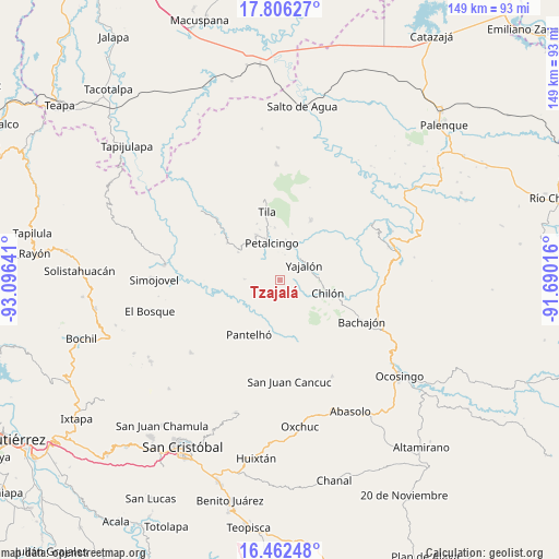
Tzajalá GPS coordinates[2]
17° 8' 8.124" North, 92° 23' 35.808" West
| Map corner | latitude | longitude |
|---|---|---|
| Upper-left | 17.80627°, | -93.09641° |
| Center: | 17.13559°, | -92.39328° |
| Lower-right: | 16.46248°, | -91.69016° |
| Map W x H: | 149.4×149.4 km | = 92.8×92.8mi |
| max Lat: | 32.7° ⇑87.3% North |
| Tzajalá: | 17.13559° |
| min Lat: | ⇓12.7% South 14.53588° |
| min Long | Tzajalá | max Long |
| -117.105° | -92.39328° | -86.73105° |
| W 92.8%⇐ | ⇒7.2% E |
Elevation
Elevation of Tzajalá is 1388 m = 4554 ft, and this is 134.3 m = 441 ft above average elevation for this country.
| Max E: |
3497 m = 11473 ft | 50.8% |
| Tzajalá | 1388 m 4554 ft | |
| Avg. | 1253.7 m = 4113 ft | |
Min E: |
-1 m = -3 ft | 49.2% |
See also: Mexico elevation on elevation.city.
Geographical zone
Tzajalá is located in North Torrid zone (between Equator and Tropic of Cancer). Distance of this Northern Tropic circle is 700.6 km =435.3 mi to North.| Distance of | km | miles | from Tzajalá |
|---|---|---|---|
| North Pole | 8101.8 | 5034.2 | to North |
| Arctic Circle | 5495.9 | 3415 | to North |
| Tropic Cancer | 700.6 | 435.3 | to North |
| Equator | 1905.3 | 1183.9 | to South |


Nearby cities:
15 places around Tzajalá: (largest is in red/bold)
• Aurora Esquipulas
9.1 km =5.7 mi,  256°
256°
• Aurora Grande
4.1 km =2.5 mi,  93°
93°
• Chilón
11.1 km =6.9 mi,  347°
347°
• El Recreo
1.3 km =0.8 mi,  42°
42°
• Emiliano Zapata
2.9 km =1.8 mi,  292°
292°
• Hidalgo Joshil
11.3 km =7 mi,  25°
25°
• Insurgente Picoté
8.4 km =5.2 mi,  172°
172°
• Juan Sabines Verapaz
10.9 km =6.8 mi,  127°
127°
• Lázaro Cárdenas
7 km =4.3 mi,  10°
10°
• Nuevo Sitalá
9.5 km =5.9 mi,  272°
272°
• Petalcingo
10.4 km =6.5 mi, 347°
• Tacuba Nueva
5.6 km =3.5 mi,  154°
154°
• Tocob Leglemal
11 km =6.8 mi, 8°
• Tzasibiltic
11.2 km =7 mi,  83°
83°
• Yajalón
7.6 km =4.7 mi,  57°
57°
Sources, notices
• [Note1] Compared only with cities in Mexico existing in our database
• [Src1] Map data: © OpenStreetMap contributors (CC-BY-SA)
• [Src2] Other city data from geonames.org with taken over terms of usage.
• [Src3] Geographical zone / Annual Mean Temperature by Robert A. Rohde @ Wikipedia
