Tacuba Nueva geodata
Tacuba Nueva (Chiapas) is a populated place; located in Mexico in America/Mexico_City (GMT-6) time zone. With population of 1,189 people, there are 7304 cities with bigger population in this country. Compared to other cities in Mexico, 87.8% of cities are located further ↑North; 93% of cities are located further ←West and 61.4% of cities have higher elevation than Tacuba Nueva. Note1


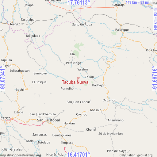
Tacuba Nueva GPS coordinates[2]
17° 5' 25.008" North, 92° 22' 13.008" West
| Map corner | latitude | longitude |
|---|---|---|
| Upper-left | 17.76113°, | -93.07341° |
| Center: | 17.09028°, | -92.37028° |
| Lower-right: | 16.41701°, | -91.66716° |
| Map W x H: | 149.5×149.5 km | = 92.9×92.9mi |
| max Lat: | 32.7° ⇑87.8% North |
| Tacuba Nueva: | 17.09028° |
| min Lat: | ⇓12.2% South 14.53588° |
| min Long | Tacuba Nueva | max Long |
| -117.105° | -92.37028° | -86.73105° |
| W 93%⇐ | ⇒7% E |
Elevation
Elevation of Tacuba Nueva is 913 m = 2995 ft, and this is 340.7 m = 1118 ft below average elevation for this country.
| Max E: |
3497 m = 11473 ft | 61.4% |
| Avg. | 1253.7 m = 4113 ft | |
| Tacuba Nueva | 913 m = 2995 ft | |
Min E: |
-1 m = -3 ft | 38.6% |
See also: Mexico elevation on elevation.city.
Geographical zone
Tacuba Nueva is located in North Torrid zone (between Equator and Tropic of Cancer). Distance of this Northern Tropic circle is 705.7 km =438.5 mi to North.| Distance of | km | miles | from Tacuba Nueva |
|---|---|---|---|
| North Pole | 8106.8 | 5037.3 | to North |
| Arctic Circle | 5500.9 | 3418.1 | to North |
| Tropic Cancer | 705.7 | 438.5 | to North |
| Equator | 1900.3 | 1180.8 | to South |


Nearby cities:
15 places around Tacuba Nueva: (largest is in red/bold)
• Aurora Esquipulas
11.6 km =7.2 mi,  284°
284°
• Aurora Grande
5.1 km =3.2 mi,  18°
18°
• Baquelchán
11.7 km =7.3 mi,  169°
169°
• Chilón
10.5 km =6.5 mi,  80°
80°
• El Recreo
6.2 km =3.9 mi,  345°
345°
• Emiliano Zapata
8 km =5 mi,  320°
320°
• Golonchán Viejo
6.7 km =4.2 mi,  193°
193°
• Insurgente Picoté
3.6 km =2.2 mi,  201°
201°
• Juan Sabines Verapaz
6.4 km =4 mi,  103°
103°
• Juc'Nil
11.4 km =7.1 mi, 204°
• Santa Cruz la Reforma
8.8 km =5.5 mi,  117°
117°
• Sitalá
10 km =6.2 mi,  137°
137°
• Tzajalá
5.6 km =3.5 mi,  334°
334°
• Tzasibiltic
10.7 km =6.6 mi,  53°
53°
• Yajalón
10 km =6.2 mi, 23°
Sources, notices
• [Note1] Compared only with cities in Mexico existing in our database
• [Src1] Map data: © OpenStreetMap contributors (CC-BY-SA)
• [Src2] Other city data from geonames.org with taken over terms of usage.
• [Src3] Geographical zone / Annual Mean Temperature by Robert A. Rohde @ Wikipedia
