Juan Sabines Verapaz geodata
Juan Sabines Verapaz (Chiapas) is a populated place; located in Mexico in America/Mexico_City (GMT-6) time zone. With population of 735 people, there are 11887 cities with bigger population in this country. Compared to other cities in Mexico, 87.9% of cities are located further ↑North; 93.3% of cities are located further ←West and 53.1% of cities have higher elevation than Juan Sabines Verapaz. Note1


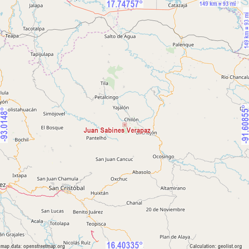
Juan Sabines Verapaz GPS coordinates[2]
17° 4' 36.012" North, 92° 18' 42.012" West
| Map corner | latitude | longitude |
|---|---|---|
| Upper-left | 17.74757°, | -93.0148° |
| Center: | 17.07667°, | -92.31167° |
| Lower-right: | 16.40335°, | -91.60855° |
| Map W x H: | 149.5×149.5 km | = 92.9×92.9mi |
| max Lat: | 32.7° ⇑87.9% North |
| Juan Sabines Verapaz: | 17.07667° |
| min Lat: | ⇓12.1% South 14.53588° |
| min Long | Juan Sabines Ve | max Long |
| -117.105° | -92.31167° | -86.73105° |
| W 93.3%⇐ | ⇒6.7% E |
Elevation
Elevation of Juan Sabines Verapaz is 1285 m = 4216 ft, and this is 31.3 m = 103 ft above average elevation for this country.
| Max E: |
3497 m = 11473 ft | 53.1% |
| Juan Sabines Verapaz | 1285 m 4216 ft | |
| Avg. | 1253.7 m = 4113 ft | |
Min E: |
-1 m = -3 ft | 46.9% |
See also: Mexico elevation on elevation.city.
Geographical zone
Juan Sabines Verapaz is located in North Torrid zone (between Equator and Tropic of Cancer). Distance of this Northern Tropic circle is 707.2 km =439.4 mi to North.| Distance of | km | miles | from Juan Sabines Verapaz |
|---|---|---|---|
| North Pole | 8108.3 | 5038.3 | to North |
| Arctic Circle | 5502.4 | 3419 | to North |
| Tropic Cancer | 707.2 | 439.4 | to North |
| Equator | 1898.7 | 1179.8 | to South |


Nearby cities:
15 places around Juan Sabines Verapaz: (largest is in red/bold)
• Aurora Grande
7.8 km =4.8 mi,  324°
324°
• Baquelchán
10.8 km =6.7 mi,  202°
202°
• Chilón
5.2 km =3.2 mi,  51°
51°
• El Recreo
10.8 km =6.7 mi,  313°
313°
• Golonchán Viejo
9.3 km =5.8 mi,  237°
237°
• Guaquitepec
11 km =6.8 mi,  166°
166°
• Insurgente Picoté
7.8 km =4.8 mi,  256°
256°
• San Antonio Bulujib
9 km =5.6 mi, 169°
• Santa Cruz la Reforma
3 km =1.9 mi,  149°
149°
• Sitalá
5.9 km =3.7 mi,  175°
175°
• Tacuba Nueva
6.4 km =4 mi,  283°
283°
• Tzajalá
10.9 km =6.8 mi, 307°
• Tzasibiltic
8.2 km =5.1 mi,  17°
17°
• Yajalón
10.9 km =6.8 mi,  347°
347°
• Yocwitz
12.8 km =8 mi,  217°
217°
Sources, notices
• [Note1] Compared only with cities in Mexico existing in our database
• [Src1] Map data: © OpenStreetMap contributors (CC-BY-SA)
• [Src2] Other city data from geonames.org with taken over terms of usage.
• [Src3] Geographical zone / Annual Mean Temperature by Robert A. Rohde @ Wikipedia
