Rincón Chamula geodata
Rincón Chamula (Chiapas) is a populated place; located in Mexico in America/Mexico_City (GMT-6) time zone. With population of 5,592 people, there are 1668 cities with bigger population in this country. Compared to other cities in Mexico, 86.5% of cities are located further ↑North; 89% of cities are located further ←West and 65.5% of cities have lower elevation than Rincón Chamula. Note1


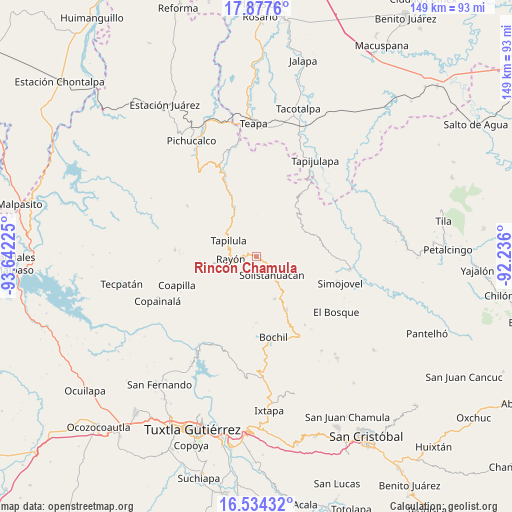
Rincón Chamula GPS coordinates[2]
17° 12' 25.848" North, 92° 56' 20.832" West
| Map corner | latitude | longitude |
|---|---|---|
| Upper-left | 17.8776°, | -93.64225° |
| Center: | 17.20718°, | -92.93912° |
| Lower-right: | 16.53432°, | -92.236° |
| Map W x H: | 149.4×149.4 km | = 92.8×92.8mi |
| max Lat: | 32.7° ⇑86.5% North |
| Rincón Chamula: | 17.20718° |
| min Lat: | ⇓13.5% South 14.53588° |
| min Long | Rincón Chamula | max Long |
| -117.105° | -92.93912° | -86.73105° |
| W 89%⇐ | ⇒11% E |
Elevation
Elevation of Rincón Chamula is 1842 m = 6043 ft, and this is 588.3 m = 1930 ft above average elevation for this country.
| Max E: |
3497 m = 11473 ft | 34.5% |
| Rincón Chamula | 1842 m 6043 ft | |
| Avg. | 1253.7 m = 4113 ft | |
Min E: |
-1 m = -3 ft | 65.5% |
See also: Mexico elevation on elevation.city.
Geographical zone
Rincón Chamula is located in North Torrid zone (between Equator and Tropic of Cancer). Distance of this Northern Tropic circle is 692.7 km =430.4 mi to North.| Distance of | km | miles | from Rincón Chamula |
|---|---|---|---|
| North Pole | 8093.8 | 5029.3 | to North |
| Arctic Circle | 5487.9 | 3410 | to North |
| Tropic Cancer | 692.7 | 430.4 | to North |
| Equator | 1913.3 | 1188.9 | to South |


Nearby cities:
15 places around Rincón Chamula: (largest is in red/bold)
• Arroyo Grande
7.3 km =4.5 mi,  103°
103°
• Aurora Ermita
7.6 km =4.7 mi,  65°
65°
• Año de Juárez
11.6 km =7.2 mi,  58°
58°
• Chapallal Grande
9.9 km =6.2 mi,  356°
356°
• El Pinabeto
2.1 km =1.3 mi,  270°
270°
• Ignacio Zaragoza
9.2 km =5.7 mi,  0°
0°
• Julián Grajales
9.6 km =6 mi,  205°
205°
• La Florida
4.5 km =2.8 mi,  343°
343°
• Lázaro Cárdenas
11 km =6.8 mi, 99°
• Pueblo Nuevo
6.7 km =4.2 mi,  141°
141°
• Rayón
7.7 km =4.8 mi, 265°
• San José Chapayal
11.6 km =7.2 mi,  26°
26°
• Santa Anita
10.8 km =6.7 mi, 337°
• Sonora
11.6 km =7.2 mi,  109°
109°
• Tapilula
9.5 km =5.9 mi,  299°
299°
Sources, notices
• [Note1] Compared only with cities in Mexico existing in our database
• [Src1] Map data: © OpenStreetMap contributors (CC-BY-SA)
• [Src2] Other city data from geonames.org with taken over terms of usage.
• [Src3] Geographical zone / Annual Mean Temperature by Robert A. Rohde @ Wikipedia
