El Carrizal geodata
El Carrizal (Chiapas) is a populated place; located in Mexico in America/Mexico_City (GMT-6) time zone. With population of 889 people, there are 9811 cities with bigger population in this country. Compared to other cities in Mexico, 86.9% of cities are located further ↑North; 88.2% of cities are located further ←West and 53.6% of cities have higher elevation than El Carrizal. Note1


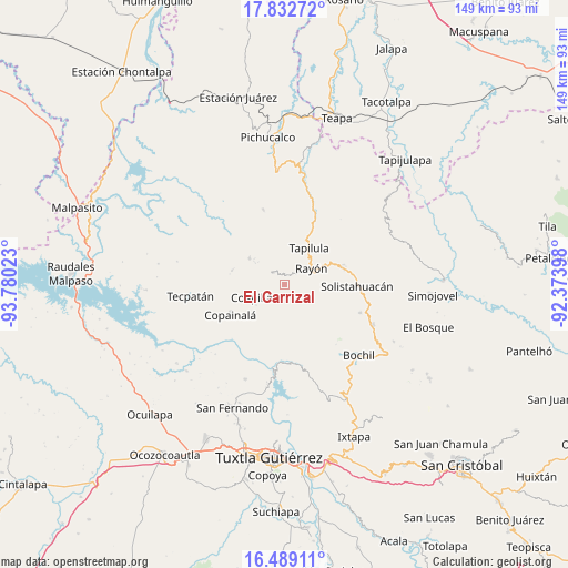
El Carrizal GPS coordinates[2]
17° 9' 43.668" North, 93° 4' 37.56" West
| Map corner | latitude | longitude |
|---|---|---|
| Upper-left | 17.83272°, | -93.78023° |
| Center: | 17.16213°, | -93.0771° |
| Lower-right: | 16.48911°, | -92.37398° |
| Map W x H: | 149.4×149.4 km | = 92.8×92.8mi |
| max Lat: | 32.7° ⇑86.9% North |
| El Carrizal: | 17.16213° |
| min Lat: | ⇓13.1% South 14.53588° |
| min Long | El Carrizal | max Long |
| -117.105° | -93.0771° | -86.73105° |
| W 88.2%⇐ | ⇒11.8% E |
Elevation
Elevation of El Carrizal is 1264 m = 4147 ft, and this is 10.3 m = 34 ft above average elevation for this country.
| Max E: |
3497 m = 11473 ft | 53.6% |
| El Carrizal | 1264 m 4147 ft | |
| Avg. | 1253.7 m = 4113 ft | |
Min E: |
-1 m = -3 ft | 46.4% |
See also: Mexico elevation on elevation.city.
Geographical zone
El Carrizal is located in North Torrid zone (between Equator and Tropic of Cancer). Distance of this Northern Tropic circle is 697.7 km =433.5 mi to North.| Distance of | km | miles | from El Carrizal |
|---|---|---|---|
| North Pole | 8098.8 | 5032.4 | to North |
| Arctic Circle | 5492.9 | 3413.1 | to North |
| Tropic Cancer | 697.7 | 433.5 | to North |
| Equator | 1908.2 | 1185.7 | to South |


Nearby cities:
15 places around El Carrizal: (largest is in red/bold)
• Buenavista (Matasanos)
6.1 km =3.8 mi,  169°
169°
• Coapilla
9.4 km =5.8 mi,  248°
248°
• El Amate
8.8 km =5.5 mi,  119°
119°
• El Triunfo
6.6 km =4.1 mi,  22°
22°
• Garrido Canaval
11.1 km =6.9 mi,  151°
151°
• José María Morelos y Pavón
11.5 km =7.1 mi,  210°
210°
• Julián Grajales
11.1 km =6.9 mi,  109°
109°
• Llano Grande
8.4 km =5.2 mi,  217°
217°
• Pantepec
4.1 km =2.5 mi,  44°
44°
• Rayón
8.3 km =5.2 mi,  58°
58°
• San Andrés Carrizal
9.2 km =5.7 mi,  310°
310°
• San Francisco Ocotal
9.8 km =6.1 mi, 307°
• San Isidro las Banderas
7.8 km =4.8 mi,  13°
13°
• Tapalapa
4.4 km =2.7 mi,  317°
317°
• Vicente Guerrero
3.8 km =2.4 mi, 151°
Sources, notices
• [Note1] Compared only with cities in Mexico existing in our database
• [Src1] Map data: © OpenStreetMap contributors (CC-BY-SA)
• [Src2] Other city data from geonames.org with taken over terms of usage.
• [Src3] Geographical zone / Annual Mean Temperature by Robert A. Rohde @ Wikipedia
