Guadalupe Victoria geodata
Guadalupe Victoria (Chiapas) is a populated place; located in Mexico in America/Mexico_City (GMT-6) time zone. With population of 1,876 people, there are 4636 cities with bigger population in this country. Compared to other cities in Mexico, 93.4% of cities are located further ↑North; 87% of cities are located further ←West and 63.3% of cities have higher elevation than Guadalupe Victoria. Note1


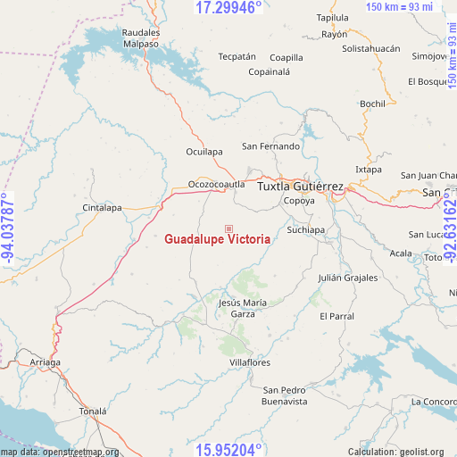
Guadalupe Victoria GPS coordinates[2]
16° 37' 36.948" North, 93° 20' 5.064" West
| Map corner | latitude | longitude |
|---|---|---|
| Upper-left | 17.29946°, | -94.03787° |
| Center: | 16.62693°, | -93.33474° |
| Lower-right: | 15.95204°, | -92.63162° |
| Map W x H: | 149.8×149.8 km | = 93.1×93.1mi |
| max Lat: | 32.7° ⇑93.4% North |
| Guadalupe Victoria: | 16.62693° |
| min Lat: | ⇓6.6% South 14.53588° |
| min Long | Guadalupe Victo | max Long |
| -117.105° | -93.33474° | -86.73105° |
| W 87%⇐ | ⇒13% E |
Elevation
Elevation of Guadalupe Victoria is 799 m = 2621 ft, and this is 454.7 m = 1492 ft below average elevation for this country.
| Max E: |
3497 m = 11473 ft | 63.3% |
| Avg. | 1253.7 m = 4113 ft | |
| Guadalupe Victoria | 799 m = 2621 ft | |
Min E: |
-1 m = -3 ft | 36.7% |
See also: Mexico elevation on elevation.city.
Geographical zone
Guadalupe Victoria is located in North Torrid zone (between Equator and Tropic of Cancer). Distance of this Northern Tropic circle is 757.2 km =470.5 mi to North.| Distance of | km | miles | from Guadalupe Victoria |
|---|---|---|---|
| North Pole | 8158.3 | 5069.3 | to North |
| Arctic Circle | 5552.4 | 3450.1 | to North |
| Tropic Cancer | 757.2 | 470.5 | to North |
| Equator | 1848.7 | 1148.7 | to South |


Nearby cities:
15 places around Guadalupe Victoria: (largest is in red/bold)
• Alfonso Moguel
18.8 km =11.7 mi,  283°
283°
• Berriozábal
20.2 km =12.6 mi,  19°
19°
• Ciudad Maya
12.7 km =7.9 mi,  9°
9°
• El Portillo
20.4 km =12.7 mi,  157°
157°
• Emiliano Zapata
13.6 km =8.5 mi,  62°
62°
• Espinal de Morelos
13.5 km =8.4 mi,  312°
312°
• Hermenegildo Galeana
6.1 km =3.8 mi,  205°
205°
• Ignacio Zaragoza (El Morro)
3.5 km =2.2 mi, 209°
• La Independencia (Las Pilas)
10.7 km =6.6 mi, 58°
• Nuevo México
20.7 km =12.9 mi, 212°
• Ocozocoautla de Espinosa
15.6 km =9.7 mi,  344°
344°
• Tenochtitlán
19.2 km =11.9 mi,  188°
188°
• Unión y Progreso
16.6 km =10.3 mi,  175°
175°
• Vicente Guerrero
9.8 km =6.1 mi,  52°
52°
• Villahermosa (Reymundo Enríquez)
13.3 km =8.3 mi,  38°
38°
Sources, notices
• [Note1] Compared only with cities in Mexico existing in our database
• [Src1] Map data: © OpenStreetMap contributors (CC-BY-SA)
• [Src2] Other city data from geonames.org with taken over terms of usage.
• [Src3] Geographical zone / Annual Mean Temperature by Robert A. Rohde @ Wikipedia
