Chuchiltón Anexo Potobtic Dos geodata
Chuchiltón Anexo Potobtic Dos (Chiapas) is a populated place; located in Mexico in America/Mexico_City (GMT-6) time zone. With population of 947 people, there are 9196 cities with bigger population in this country. Compared to other cities in Mexico, 89.3% of cities are located further ↑North; 89.5% of cities are located further ←West and 55.1% of cities have lower elevation than Chuchiltón Anexo Potobtic Dos. Note1
Current local time in Chuchiltón Anexo Potobtic Dos:
08:33 AM, WednesdayDifference from your time zone: hours


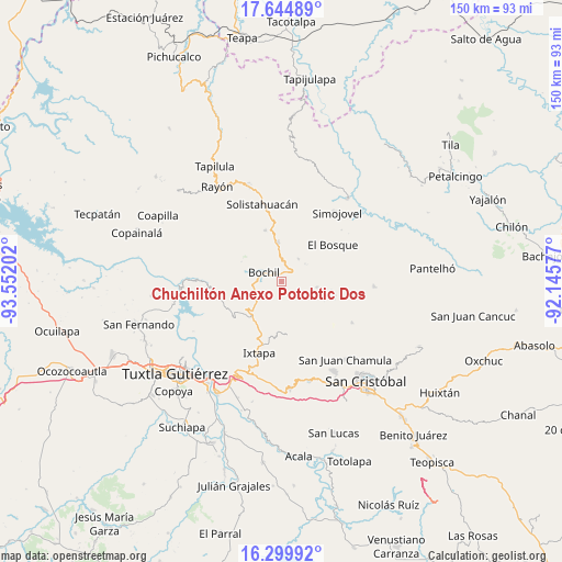
Chuchiltón Anexo Potobtic Dos GPS coordinates[2]
16° 58' 24.996" North, 92° 50' 56.004" West
| Map corner | latitude | longitude |
|---|---|---|
| Upper-left | 17.64489°, | -93.55202° |
| Center: | 16.97361°, | -92.84889° |
| Lower-right: | 16.29992°, | -92.14577° |
| Map W x H: | 149.5×149.5 km | = 92.9×92.9mi |
| max Lat: | 32.7° ⇑89.3% North |
| Chuchiltón Anexo Potobtic Dos: | 16.97361° |
| min Lat: | ⇓10.7% South 14.53588° |
| min Long | Chuchiltón Ane | max Long |
| -117.105° | -92.84889° | -86.73105° |
| W 89.5%⇐ | ⇒10.5% E |
Elevation
Elevation of Chuchiltón Anexo Potobtic Dos is 1590 m = 5217 ft, and this is 336.3 m = 1103 ft above average elevation for this country.
| Max E: |
3497 m = 11473 ft | 44.9% |
| Chuchiltón Anexo Potobtic Dos | 1590 m 5217 ft | |
| Avg. | 1253.7 m = 4113 ft | |
Min E: |
-1 m = -3 ft | 55.1% |
See also: Mexico elevation on elevation.city.
Geographical zone
Chuchiltón Anexo Potobtic Dos is located in North Torrid zone (between Equator and Tropic of Cancer). Distance of this Northern Tropic circle is 718.6 km =446.5 mi to North.| Distance of | km | miles | from Chuchiltón Anexo Potobtic Dos |
|---|---|---|---|
| North Pole | 8119.8 | 5045.4 | to North |
| Arctic Circle | 5513.9 | 3426.2 | to North |
| Tropic Cancer | 718.6 | 446.5 | to North |
| Equator | 1887.3 | 1172.7 | to South |


Nearby cities:
15 places around Chuchiltón Anexo Potobtic Dos: (largest is in red/bold)
• Bochil
5.2 km =3.2 mi,  298°
298°
• Buenavista
4.6 km =2.9 mi,  176°
176°
• Chuchiltón
2.6 km =1.6 mi,  131°
131°
• El Copal
8.3 km =5.2 mi,  265°
265°
• El Nopal
6.9 km =4.3 mi, 176°
• El Ámbar
5.9 km =3.7 mi,  15°
15°
• Majoval
3.5 km =2.2 mi,  47°
47°
• Monte Grande
4.2 km =2.6 mi,  200°
200°
• San Cristobalito
7.5 km =4.7 mi,  155°
155°
• San Vicente
8.2 km =5.1 mi,  255°
255°
• Stenlejsotztetic
5.6 km =3.5 mi,  154°
154°
• Tierra Colorada
8.4 km =5.2 mi, 303°
• Venustiano Carranza
8.7 km =5.4 mi, 261°
• Yerbabuena Isbontick
4.9 km =3 mi, 201°
• Álvaro Obregón
7.6 km =4.7 mi,  35°
35°
Sources, notices
• [Note1] Compared only with cities in Mexico existing in our database
• [Src1] Map data: © OpenStreetMap contributors (CC-BY-SA)
• [Src2] Other city data from geonames.org with taken over terms of usage.
• [Src3] Geographical zone / Annual Mean Temperature by Robert A. Rohde @ Wikipedia
