Buenavista geodata
Buenavista (Chiapas) is a populated place; located in Mexico in America/Mexico_City (GMT-6) time zone. With population of 571 people, there are 14980 cities with bigger population in this country. Compared to other cities in Mexico, 93.1% of cities are located further ↑North; 92.5% of cities are located further ←West and 86.1% of cities have lower elevation than Buenavista. Note1


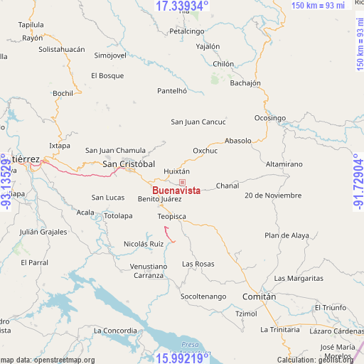
Buenavista GPS coordinates[2]
16° 40' 1.02" North, 92° 25' 55.776" West
| Map corner | latitude | longitude |
|---|---|---|
| Upper-left | 17.33934°, | -93.13529° |
| Center: | 16.66695°, | -92.43216° |
| Lower-right: | 15.99219°, | -91.72904° |
| Map W x H: | 149.8×149.8 km | = 93.1×93.1mi |
| max Lat: | 32.7° ⇑93.1% North |
| Buenavista: | 16.66695° |
| min Lat: | ⇓6.9% South 14.53588° |
| min Long | Buenavista | max Long |
| -117.105° | -92.43216° | -86.73105° |
| W 92.5%⇐ | ⇒7.5% E |
Elevation
Elevation of Buenavista is 2285 m = 7497 ft, and this is 1031.3 m = 3384 ft above average elevation for this country.
| Max E: |
3497 m = 11473 ft | 13.9% |
| Buenavista | 2285 m 7497 ft | |
| Avg. | 1253.7 m = 4113 ft | |
Min E: |
-1 m = -3 ft | 86.1% |
See also: Mexico elevation on elevation.city.
Geographical zone
Buenavista is located in North Torrid zone (between Equator and Tropic of Cancer). Distance of this Northern Tropic circle is 752.7 km =467.7 mi to North.| Distance of | km | miles | from Buenavista |
|---|---|---|---|
| North Pole | 8153.9 | 5066.6 | to North |
| Arctic Circle | 5548 | 3447.4 | to North |
| Tropic Cancer | 752.7 | 467.7 | to North |
| Equator | 1853.2 | 1151.5 | to South |


Nearby cities:
15 places around Buenavista: (largest is in red/bold)
• Adolfo López Mateos
9.6 km =6 mi,  11°
11°
• Carmen Yalchuch
7.8 km =4.8 mi,  108°
108°
• Chanal
6.5 km =4 mi,  31°
31°
• Dos Lagunas (San Isidro)
7.5 km =4.7 mi,  180°
180°
• El Escalón
10.1 km =6.3 mi,  295°
295°
• Eshpuilho
6.6 km =4.1 mi,  316°
316°
• Huixtán
5.3 km =3.3 mi,  335°
335°
• La Soledad
9.4 km =5.8 mi,  276°
276°
• Los Pozos
3.4 km =2.1 mi,  128°
128°
• Lázaro Cárdenas (Chilil)
6.2 km =3.9 mi, 279°
• Oquem
8.1 km =5 mi, 322°
• San Andrés Puerto Rico
4.8 km =3 mi,  40°
40°
• San Gregorio de las Casas
5.1 km =3.2 mi,  63°
63°
• San José Yashitinín
1.9 km =1.2 mi,  225°
225°
• Tzajalha
8.1 km =5 mi,  207°
207°
Sources, notices
• [Note1] Compared only with cities in Mexico existing in our database
• [Src1] Map data: © OpenStreetMap contributors (CC-BY-SA)
• [Src2] Other city data from geonames.org with taken over terms of usage.
• [Src3] Geographical zone / Annual Mean Temperature by Robert A. Rohde @ Wikipedia
