El Escalón geodata
El Escalón (Chiapas) is a populated place; located in Mexico in America/Mexico_City (GMT-6) time zone. With population of 615 people, there are 14017 cities with bigger population in this country. Compared to other cities in Mexico, 92.8% of cities are located further ↑North; 91.7% of cities are located further ←West and 88.6% of cities have lower elevation than El Escalón. Note1


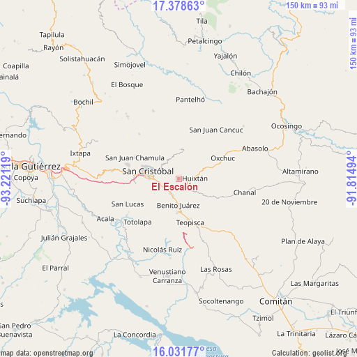
El Escalón GPS coordinates[2]
16° 42' 23.004" North, 92° 31' 5.016" West
| Map corner | latitude | longitude |
|---|---|---|
| Upper-left | 17.37863°, | -93.22119° |
| Center: | 16.70639°, | -92.51806° |
| Lower-right: | 16.03177°, | -91.81494° |
| Map W x H: | 149.8×149.8 km | = 93.1×93.1mi |
| max Lat: | 32.7° ⇑92.8% North |
| El Escalón: | 16.70639° |
| min Lat: | ⇓7.2% South 14.53588° |
| min Long | El Escalón | max Long |
| -117.105° | -92.51806° | -86.73105° |
| W 91.7%⇐ | ⇒8.3% E |
Elevation
Elevation of El Escalón is 2360 m = 7743 ft, and this is 1106.3 m = 3630 ft above average elevation for this country.
| Max E: |
3497 m = 11473 ft | 11.4% |
| El Escalón | 2360 m 7743 ft | |
| Avg. | 1253.7 m = 4113 ft | |
Min E: |
-1 m = -3 ft | 88.6% |
See also: Mexico elevation on elevation.city.
Geographical zone
El Escalón is located in North Torrid zone (between Equator and Tropic of Cancer). Distance of this Northern Tropic circle is 748.3 km =465 mi to North.| Distance of | km | miles | from El Escalón |
|---|---|---|---|
| North Pole | 8149.5 | 5063.9 | to North |
| Arctic Circle | 5543.6 | 3444.6 | to North |
| Tropic Cancer | 748.3 | 465 | to North |
| Equator | 1857.6 | 1154.3 | to South |


Nearby cities:
15 places around El Escalón: (largest is in red/bold)
• Agua de Pajarito
6.2 km =3.9 mi,  302°
302°
• Corazón de María
1.9 km =1.2 mi,  246°
246°
• Cruztón
9 km =5.6 mi,  313°
313°
• El Aguaje (La Albarada)
8 km =5 mi, 254°
• Eshpuilho
4.6 km =2.9 mi,  84°
84°
• Huixtán
6.9 km =4.3 mi,  86°
86°
• Jocosic
9.1 km =5.7 mi,  45°
45°
• La Candelaria
4.1 km =2.5 mi,  354°
354°
• La Sierra
2.8 km =1.7 mi,  286°
286°
• La Soledad
3.3 km =2.1 mi,  182°
182°
• Lázaro Cárdenas (Chilil)
4.6 km =2.9 mi,  137°
137°
• Mitzitón
7.2 km =4.5 mi,  201°
201°
• Oquem
4.6 km =2.9 mi,  64°
64°
• Romerillo
8.4 km =5.2 mi,  321°
321°
• San Pedro la Tejería
2.6 km =1.6 mi,  19°
19°
Sources, notices
• [Note1] Compared only with cities in Mexico existing in our database
• [Src1] Map data: © OpenStreetMap contributors (CC-BY-SA)
• [Src2] Other city data from geonames.org with taken over terms of usage.
• [Src3] Geographical zone / Annual Mean Temperature by Robert A. Rohde @ Wikipedia
