Rancho del Cura geodata
Rancho del Cura (Chiapas) is a populated place; located in Mexico in America/Mexico_City (GMT-6) time zone. With population of 692 people, there are 12576 cities with bigger population in this country. Compared to other cities in Mexico, 92.6% of cities are located further ↑North; 93.8% of cities are located further ←West and 73.1% of cities have lower elevation than Rancho del Cura. Note1


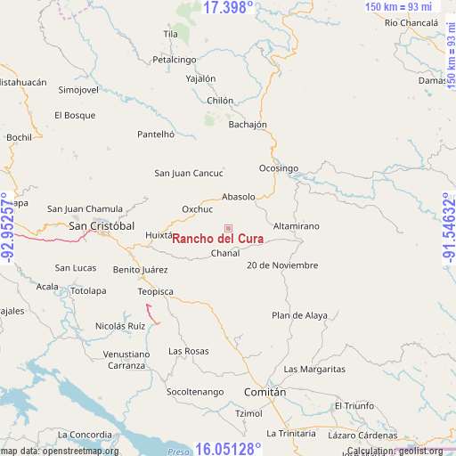
Rancho del Cura GPS coordinates[2]
16° 43' 32.988" North, 92° 14' 57.984" West
| Map corner | latitude | longitude |
|---|---|---|
| Upper-left | 17.398°, | -92.95257° |
| Center: | 16.72583°, | -92.24944° |
| Lower-right: | 16.05128°, | -91.54632° |
| Map W x H: | 149.7×149.7 km | = 93×93mi |
| max Lat: | 32.7° ⇑92.6% North |
| Rancho del Cura: | 16.72583° |
| min Lat: | ⇓7.4% South 14.53588° |
| min Long | Rancho del Cura | max Long |
| -117.105° | -92.24944° | -86.73105° |
| W 93.8%⇐ | ⇒6.2% E |
Elevation
Elevation of Rancho del Cura is 1991 m = 6532 ft, and this is 737.3 m = 2419 ft above average elevation for this country.
| Max E: |
3497 m = 11473 ft | 26.9% |
| Rancho del Cura | 1991 m 6532 ft | |
| Avg. | 1253.7 m = 4113 ft | |
Min E: |
-1 m = -3 ft | 73.1% |
See also: Mexico elevation on elevation.city.
Geographical zone
Rancho del Cura is located in North Torrid zone (between Equator and Tropic of Cancer). Distance of this Northern Tropic circle is 746.2 km =463.7 mi to North.| Distance of | km | miles | from Rancho del Cura |
|---|---|---|---|
| North Pole | 8147.3 | 5062.5 | to North |
| Arctic Circle | 5541.4 | 3443.3 | to North |
| Tropic Cancer | 746.2 | 463.7 | to North |
| Equator | 1859.7 | 1155.6 | to South |


Nearby cities:
15 places around Rancho del Cura: (largest is in red/bold)
• Abasolo
11.2 km =7 mi,  18°
18°
• Benito Juárez
8 km =5 mi,  102°
102°
• Chanal
7.6 km =4.7 mi,  186°
186°
• Chulna
9.8 km =6.1 mi,  45°
45°
• Cuxuljá
12.7 km =7.9 mi,  40°
40°
• El Corralito
10.6 km =6.6 mi,  357°
357°
• Guadalupe Bacja
1.5 km =0.9 mi,  195°
195°
• La Independencia
9.8 km =6.1 mi,  269°
269°
• La Libertad
10.8 km =6.7 mi,  264°
264°
• Oxchuc
12.1 km =7.5 mi,  303°
303°
• Palomar 2
12 km =7.5 mi, 23°
• Puilja
5 km =3.1 mi,  5°
5°
• San Fernando
7 km =4.3 mi,  223°
223°
• San Pedro Pedernal
10.4 km =6.5 mi,  228°
228°
• Tzopilja
6.5 km =4 mi,  283°
283°
Sources, notices
• [Note1] Compared only with cities in Mexico existing in our database
• [Src1] Map data: © OpenStreetMap contributors (CC-BY-SA)
• [Src2] Other city data from geonames.org with taken over terms of usage.
• [Src3] Geographical zone / Annual Mean Temperature by Robert A. Rohde @ Wikipedia
