Cuxuljá geodata
Cuxuljá (Chiapas) is a populated place; located in Mexico in America/Mexico_City (GMT-6) time zone. With population of 718 people, there are 12143 cities with bigger population in this country. Compared to other cities in Mexico, 91.6% of cities are located further ↑North; 94.4% of cities are located further ←West and 54% of cities have higher elevation than Cuxuljá. Note1


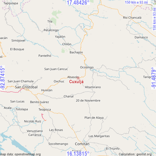
Cuxuljá GPS coordinates[2]
16° 48' 44.64" North, 92° 10' 15.672" West
| Map corner | latitude | longitude |
|---|---|---|
| Upper-left | 17.48426°, | -92.87415° |
| Center: | 16.8124°, | -92.17102° |
| Lower-right: | 16.13815°, | -91.4679° |
| Map W x H: | 149.7×149.7 km | = 93×93mi |
| max Lat: | 32.7° ⇑91.6% North |
| Cuxuljá: | 16.8124° |
| min Lat: | ⇓8.4% South 14.53588° |
| min Long | Cuxuljá | max Long |
| -117.105° | -92.17102° | -86.73105° |
| W 94.4%⇐ | ⇒5.6% E |
Elevation
Elevation of Cuxuljá is 1241 m = 4072 ft, and this is 12.7 m = 42 ft below average elevation for this country.
| Max E: |
3497 m = 11473 ft | 54% |
| Avg. | 1253.7 m = 4113 ft | |
| Cuxuljá | 1241 m = 4072 ft | |
Min E: |
-1 m = -3 ft | 46% |
See also: Mexico elevation on elevation.city.
Geographical zone
Cuxuljá is located in North Torrid zone (between Equator and Tropic of Cancer). Distance of this Northern Tropic circle is 736.6 km =457.7 mi to North.| Distance of | km | miles | from Cuxuljá |
|---|---|---|---|
| North Pole | 8137.7 | 5056.5 | to North |
| Arctic Circle | 5531.8 | 3437.3 | to North |
| Tropic Cancer | 736.6 | 457.7 | to North |
| Equator | 1869.4 | 1161.6 | to South |


Nearby cities:
15 places around Cuxuljá: (largest is in red/bold)
• Abasolo
4.9 km =3 mi,  281°
281°
• Altamirano
8.2 km =5.1 mi,  15°
15°
• Benito Juárez
11.3 km =7 mi,  182°
182°
• Chulna
3.1 km =1.9 mi,  207°
207°
• El Corralito
8.9 km =5.5 mi, 276°
• Guadalupe Bacja
14.1 km =8.8 mi,  218°
218°
• La Virginia
7.2 km =4.5 mi,  357°
357°
• Los Pinos
13.8 km =8.6 mi,  28°
28°
• Nuevo Paraíso
13.6 km =8.5 mi,  51°
51°
• Ocosingo
13.3 km =8.3 mi,  38°
38°
• Palomar 2
3.9 km =2.4 mi,  291°
291°
• Puilja
9.2 km =5.7 mi,  239°
239°
• Rancho del Cura
12.7 km =7.9 mi, 220°
• Sibacá
13.6 km =8.5 mi,  14°
14°
• Tenango
14.1 km =8.8 mi,  316°
316°
Sources, notices
• [Note1] Compared only with cities in Mexico existing in our database
• [Src1] Map data: © OpenStreetMap contributors (CC-BY-SA)
• [Src2] Other city data from geonames.org with taken over terms of usage.
• [Src3] Geographical zone / Annual Mean Temperature by Robert A. Rohde @ Wikipedia
