Chulna geodata
Chulna (Chiapas) is a populated place; located in Mexico in America/Mexico_City (GMT-6) time zone. With population of 602 people, there are 14290 cities with bigger population in this country. Compared to other cities in Mexico, 91.9% of cities are located further ↑North; 94.3% of cities are located further ←West and 52.9% of cities have higher elevation than Chulna. Note1


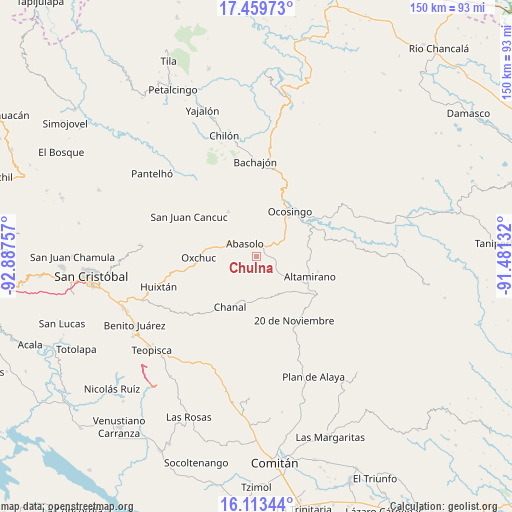
Chulna GPS coordinates[2]
16° 47' 16.008" North, 92° 11' 3.984" West
| Map corner | latitude | longitude |
|---|---|---|
| Upper-left | 17.45973°, | -92.88757° |
| Center: | 16.78778°, | -92.18444° |
| Lower-right: | 16.11344°, | -91.48132° |
| Map W x H: | 149.7×149.7 km | = 93×93mi |
| max Lat: | 32.7° ⇑91.9% North |
| Chulna: | 16.78778° |
| min Lat: | ⇓8.1% South 14.53588° |
| min Long | Chulna | max Long |
| -117.105° | -92.18444° | -86.73105° |
| W 94.3%⇐ | ⇒5.7% E |
Elevation
Elevation of Chulna is 1297 m = 4255 ft, and this is 43.3 m = 142 ft above average elevation for this country.
| Max E: |
3497 m = 11473 ft | 52.9% |
| Chulna | 1297 m 4255 ft | |
| Avg. | 1253.7 m = 4113 ft | |
Min E: |
-1 m = -3 ft | 47.1% |
See also: Mexico elevation on elevation.city.
Geographical zone
Chulna is located in North Torrid zone (between Equator and Tropic of Cancer). Distance of this Northern Tropic circle is 739.3 km =459.4 mi to North.| Distance of | km | miles | from Chulna |
|---|---|---|---|
| North Pole | 8140.4 | 5058.2 | to North |
| Arctic Circle | 5534.5 | 3439 | to North |
| Tropic Cancer | 739.3 | 459.4 | to North |
| Equator | 1866.6 | 1159.9 | to South |


Nearby cities:
15 places around Chulna: (largest is in red/bold)
• Abasolo
5 km =3.1 mi,  317°
317°
• Altamirano
11.2 km =7 mi,  19°
19°
• Benito Juárez
8.6 km =5.3 mi,  174°
174°
• Cuxuljá
3.1 km =1.9 mi,  27°
27°
• El Corralito
8.3 km =5.2 mi,  296°
296°
• El Tzay
16 km =9.9 mi, 301°
• Guadalupe Bacja
11.1 km =6.9 mi,  221°
221°
• Joaquín Miguel Gutiérrez
16.4 km =10.2 mi,  78°
78°
• La Virginia
10 km =6.2 mi,  6°
6°
• Ocosingo
16.3 km =10.1 mi,  36°
36°
• Palomar 2
4.7 km =2.9 mi,  332°
332°
• Puilja
6.8 km =4.2 mi,  253°
253°
• Rancho del Cura
9.8 km =6.1 mi,  225°
225°
• Tenango
15.4 km =9.6 mi, 327°
• Tzopilja
14.3 km =8.9 mi, 248°
Sources, notices
• [Note1] Compared only with cities in Mexico existing in our database
• [Src1] Map data: © OpenStreetMap contributors (CC-BY-SA)
• [Src2] Other city data from geonames.org with taken over terms of usage.
• [Src3] Geographical zone / Annual Mean Temperature by Robert A. Rohde @ Wikipedia
