Palomar 2 geodata
Palomar 2 (Chiapas) is a populated place; located in Mexico in America/Mexico_City (GMT-6) time zone. With population of 667 people, there are 13011 cities with bigger population in this country. Compared to other cities in Mexico, 91.3% of cities are located further ↑North; 94.1% of cities are located further ←West and 53.8% of cities have higher elevation than Palomar 2. Note1


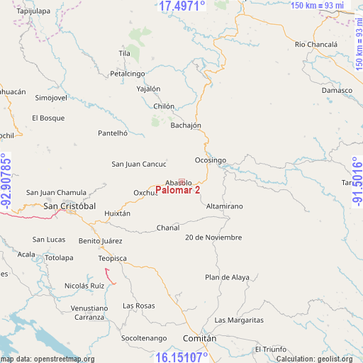
Palomar 2 GPS coordinates[2]
16° 49' 31.008" North, 92° 12' 16.992" West
| Map corner | latitude | longitude |
|---|---|---|
| Upper-left | 17.4971°, | -92.90785° |
| Center: | 16.82528°, | -92.20472° |
| Lower-right: | 16.15107°, | -91.5016° |
| Map W x H: | 149.7×149.7 km | = 93×93mi |
| max Lat: | 32.7° ⇑91.3% North |
| Palomar 2: | 16.82528° |
| min Lat: | ⇓8.7% South 14.53588° |
| min Long | Palomar 2 | max Long |
| -117.105° | -92.20472° | -86.73105° |
| W 94.1%⇐ | ⇒5.9% E |
Elevation
Elevation of Palomar 2 is 1254 m = 4114 ft, and this is 0.29999999999995 m = 1 ft above average elevation for this country.
| Max E: |
3497 m = 11473 ft | 53.8% |
| Palomar 2 | 1254 m 4114 ft | |
| Avg. | 1253.7 m = 4113 ft | |
Min E: |
-1 m = -3 ft | 46.2% |
See also: Mexico elevation on elevation.city.
Geographical zone
Palomar 2 is located in North Torrid zone (between Equator and Tropic of Cancer). Distance of this Northern Tropic circle is 735.1 km =456.8 mi to North.| Distance of | km | miles | from Palomar 2 |
|---|---|---|---|
| North Pole | 8136.3 | 5055.7 | to North |
| Arctic Circle | 5530.4 | 3436.4 | to North |
| Tropic Cancer | 735.1 | 456.8 | to North |
| Equator | 1870.8 | 1162.5 | to South |


Nearby cities:
15 places around Palomar 2: (largest is in red/bold)
• Abasolo
1.3 km =0.8 mi,  250°
250°
• Altamirano
8.7 km =5.4 mi,  42°
42°
• Benito Juárez
13.1 km =8.1 mi,  166°
166°
• Chulna
4.7 km =2.9 mi,  152°
152°
• Cruztón
14.3 km =8.9 mi,  278°
278°
• Cuxuljá
3.9 km =2.4 mi,  111°
111°
• El Corralito
5.3 km =3.3 mi,  264°
264°
• El Tzay
12.2 km =7.6 mi,  290°
290°
• Guadalupe Bacja
13.5 km =8.4 mi,  202°
202°
• La Virginia
6.6 km =4.1 mi,  29°
29°
• Puilja
7.5 km =4.7 mi,  215°
215°
• Rancho del Cura
12 km =7.5 mi, 203°
• Sibacá
13.6 km =8.5 mi, 30°
• Tenango
10.7 km =6.6 mi,  325°
325°
• Tzopilja
14.6 km =9.1 mi,  229°
229°
Sources, notices
• [Note1] Compared only with cities in Mexico existing in our database
• [Src1] Map data: © OpenStreetMap contributors (CC-BY-SA)
• [Src2] Other city data from geonames.org with taken over terms of usage.
• [Src3] Geographical zone / Annual Mean Temperature by Robert A. Rohde @ Wikipedia
