La Laguna geodata
La Laguna (Chiapas) is a populated place; located in Mexico in America/Mexico_City (GMT-6) time zone. With population of 1,222 people, there are 7104 cities with bigger population in this country. Compared to other cities in Mexico, 92.9% of cities are located further ↑North; 95.5% of cities are located further ←West and 54.3% of cities have higher elevation than La Laguna. Note1


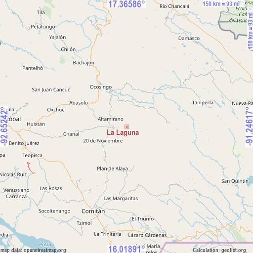
La Laguna GPS coordinates[2]
16° 41' 36.852" North, 91° 56' 57.444" West
| Map corner | latitude | longitude |
|---|---|---|
| Upper-left | 17.36586°, | -92.65242° |
| Center: | 16.69357°, | -91.94929° |
| Lower-right: | 16.01891°, | -91.24617° |
| Map W x H: | 149.8×149.8 km | = 93.1×93.1mi |
| max Lat: | 32.7° ⇑92.9% North |
| La Laguna: | 16.69357° |
| min Lat: | ⇓7.1% South 14.53588° |
| min Long | La Laguna | max Long |
| -117.105° | -91.94929° | -86.73105° |
| W 95.5%⇐ | ⇒4.5% E |
Elevation
Elevation of La Laguna is 1226 m = 4022 ft, and this is 27.7 m = 91 ft below average elevation for this country.
| Max E: |
3497 m = 11473 ft | 54.3% |
| Avg. | 1253.7 m = 4113 ft | |
| La Laguna | 1226 m = 4022 ft | |
Min E: |
-1 m = -3 ft | 45.7% |
See also: Mexico elevation on elevation.city.
Geographical zone
La Laguna is located in North Torrid zone (between Equator and Tropic of Cancer). Distance of this Northern Tropic circle is 749.8 km =465.9 mi to North.| Distance of | km | miles | from La Laguna |
|---|---|---|---|
| North Pole | 8150.9 | 5064.7 | to North |
| Arctic Circle | 5545 | 3445.5 | to North |
| Tropic Cancer | 749.8 | 465.9 | to North |
| Equator | 1856.2 | 1153.4 | to South |


Nearby cities:
15 places around La Laguna: (largest is in red/bold)
• Altamirano
10.5 km =6.5 mi,  295°
295°
• Belisario Domínguez
22.6 km =14 mi,  103°
103°
• Carmen Rusia
17.7 km =11 mi,  137°
137°
• El Triunfo
20.6 km =12.8 mi, 95°
• El Vergel
19 km =11.8 mi,  227°
227°
• Joaquín Miguel Gutiérrez
16.5 km =10.3 mi,  326°
326°
• Justo Sierra
20.4 km =12.7 mi,  214°
214°
• La Ilusión
16.5 km =10.3 mi, 230°
• Morelia (Victórico Rodolfo Grajales)
3.8 km =2.4 mi, 329°
• Nuevo México
20 km =12.4 mi, 226°
• Nuevo San Carlos
1.9 km =1.2 mi,  269°
269°
• San Caralampio
14.5 km =9 mi,  187°
187°
• San Miguel
15.5 km =9.6 mi,  42°
42°
• Santa Rita Sonora
20.7 km =12.9 mi,  200°
200°
• Veinte de Noviembre
16.3 km =10.1 mi,  239°
239°
Sources, notices
• [Note1] Compared only with cities in Mexico existing in our database
• [Src1] Map data: © OpenStreetMap contributors (CC-BY-SA)
• [Src2] Other city data from geonames.org with taken over terms of usage.
• [Src3] Geographical zone / Annual Mean Temperature by Robert A. Rohde @ Wikipedia
