El Zapotal geodata
El Zapotal (Chiapas) is a populated place; located in Mexico in America/Mexico_City (GMT-6) time zone. With population of 1,385 people, there are 6250 cities with bigger population in this country. Compared to other cities in Mexico, 92.3% of cities are located further ↑North; 96.4% of cities are located further ←West and 66.1% of cities have higher elevation than El Zapotal. Note1


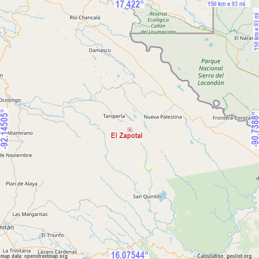
El Zapotal GPS coordinates[2]
16° 44' 59.676" North, 91° 26' 30.912" West
| Map corner | latitude | longitude |
|---|---|---|
| Upper-left | 17.422°, | -92.14505° |
| Center: | 16.74991°, | -91.44192° |
| Lower-right: | 16.07544°, | -90.7388° |
| Map W x H: | 149.7×149.7 km | = 93×93mi |
| max Lat: | 32.7° ⇑92.3% North |
| El Zapotal: | 16.74991° |
| min Lat: | ⇓7.7% South 14.53588° |
| min Long | El Zapotal | max Long |
| -117.105° | -91.44192° | -86.73105° |
| W 96.4%⇐ | ⇒3.6% E |
Elevation
Elevation of El Zapotal is 630 m = 2067 ft, and this is 623.7 m = 2046 ft below average elevation for this country.
| Max E: |
3497 m = 11473 ft | 66.1% |
| Avg. | 1253.7 m = 4113 ft | |
| El Zapotal | 630 m = 2067 ft | |
Min E: |
-1 m = -3 ft | 33.9% |
See also: Mexico elevation on elevation.city.
Geographical zone
El Zapotal is located in North Torrid zone (between Equator and Tropic of Cancer). Distance of this Northern Tropic circle is 743.5 km =462 mi to North.| Distance of | km | miles | from El Zapotal |
|---|---|---|---|
| North Pole | 8144.6 | 5060.8 | to North |
| Arctic Circle | 5538.8 | 3441.6 | to North |
| Tropic Cancer | 743.5 | 462 | to North |
| Equator | 1862.4 | 1157.2 | to South |


Nearby cities:
15 places around El Zapotal: (largest is in red/bold)
• Agua Azul
11.3 km =7 mi,  309°
309°
• Cintalapa
21.1 km =13.1 mi,  23°
23°
• El Censo
17.8 km =11.1 mi,  315°
315°
• El Prado Pacayal
25.3 km =15.7 mi,  251°
251°
• Las Tazas
18.4 km =11.4 mi,  272°
272°
• Nueva Palestina
20.8 km =12.9 mi,  68°
68°
• Perla de Acapulco
6.4 km =4 mi, 323°
• Plan de Ayutla
15.7 km =9.8 mi,  64°
64°
• San Caralampio
2.2 km =1.4 mi,  126°
126°
• San José
6.5 km =4 mi, 132°
• San Juan Rómulo Calzada
22.3 km =13.9 mi,  234°
234°
• Santa Elena
22.4 km =13.9 mi, 315°
• Santa Rita
18.9 km =11.7 mi,  354°
354°
• Santo Tomás
12.1 km =7.5 mi,  256°
256°
• Taniperla
11.8 km =7.3 mi, 312°
Sources, notices
• [Note1] Compared only with cities in Mexico existing in our database
• [Src1] Map data: © OpenStreetMap contributors (CC-BY-SA)
• [Src2] Other city data from geonames.org with taken over terms of usage.
• [Src3] Geographical zone / Annual Mean Temperature by Robert A. Rohde @ Wikipedia
