Buenavista geodata
Buenavista (Chiapas) is a populated place; located in Mexico in America/Mexico_City (GMT-6) time zone. With population of 1,403 people, there are 6174 cities with bigger population in this country. Compared to other cities in Mexico, 96.1% of cities are located further ↑North; 95.3% of cities are located further ←West and 52% of cities have lower elevation than Buenavista. Note1


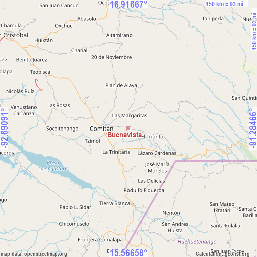
Buenavista GPS coordinates[2]
16° 14' 34.008" North, 91° 59' 16.008" West
| Map corner | latitude | longitude |
|---|---|---|
| Upper-left | 16.91667°, | -92.69091° |
| Center: | 16.24278°, | -91.98778° |
| Lower-right: | 15.56658°, | -91.28466° |
| Map W x H: | 150.1×150.1 km | = 93.3×93.3mi |
| max Lat: | 32.7° ⇑96.1% North |
| Buenavista: | 16.24278° |
| min Lat: | ⇓3.9% South 14.53588° |
| min Long | Buenavista | max Long |
| -117.105° | -91.98778° | -86.73105° |
| W 95.3%⇐ | ⇒4.7% E |
Elevation
Elevation of Buenavista is 1525 m = 5003 ft, and this is 271.3 m = 890 ft above average elevation for this country.
| Max E: |
3497 m = 11473 ft | 48% |
| Buenavista | 1525 m 5003 ft | |
| Avg. | 1253.7 m = 4113 ft | |
Min E: |
-1 m = -3 ft | 52% |
See also: Mexico elevation on elevation.city.
Geographical zone
Buenavista is located in North Torrid zone (between Equator and Tropic of Cancer). Distance of this Northern Tropic circle is 799.9 km =497 mi to North.| Distance of | km | miles | from Buenavista |
|---|---|---|---|
| North Pole | 8201 | 5095.9 | to North |
| Arctic Circle | 5595.1 | 3476.6 | to North |
| Tropic Cancer | 799.9 | 497 | to North |
| Equator | 1806 | 1122.2 | to South |


Nearby cities:
15 places around Buenavista: (largest is in red/bold)
• Cajcam
7.2 km =4.5 mi,  291°
291°
• Chentón
4 km =2.5 mi,  180°
180°
• El Campamento
6.7 km =4.2 mi,  22°
22°
• El Rosario
2.7 km =1.7 mi,  198°
198°
• Emiliano Zapata
7.1 km =4.4 mi,  162°
162°
• Francisco Sarabia
2.7 km =1.7 mi,  78°
78°
• Galeana
2.4 km =1.5 mi,  215°
215°
• Guadalupe Quistaj
5.9 km =3.7 mi,  236°
236°
• La Independencia
4 km =2.5 mi, 285°
• La Patria
8.3 km =5.2 mi,  100°
100°
• Las Margaritas
7.8 km =4.8 mi,  5°
5°
• Primero de Mayo
6.5 km =4 mi,  314°
314°
• Quistajito
2.6 km =1.6 mi, 243°
• San Antonio Chiquinivaltic
6.9 km =4.3 mi,  92°
92°
• Venustiano Carranza
8.7 km =5.4 mi,  132°
132°
Sources, notices
• [Note1] Compared only with cities in Mexico existing in our database
• [Src1] Map data: © OpenStreetMap contributors (CC-BY-SA)
• [Src2] Other city data from geonames.org with taken over terms of usage.
• [Src3] Geographical zone / Annual Mean Temperature by Robert A. Rohde @ Wikipedia
