Villahermosa Yaluma geodata
Villahermosa Yaluma (Chiapas) is a populated place; located in Mexico in America/Mexico_City (GMT-6) time zone. With population of 2,368 people, there are 3727 cities with bigger population in this country. Compared to other cities in Mexico, 95.4% of cities are located further ↑North; 94.9% of cities are located further ←West and 60.2% of cities have lower elevation than Villahermosa Yaluma. Note1


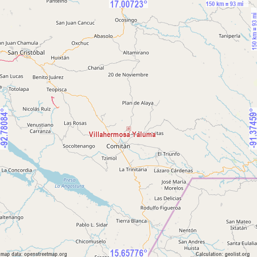
Villahermosa Yaluma GPS coordinates[2]
16° 20' 1.176" North, 92° 4' 39.756" West
| Map corner | latitude | longitude |
|---|---|---|
| Upper-left | 17.00723°, | -92.78084° |
| Center: | 16.33366°, | -92.07771° |
| Lower-right: | 15.65776°, | -91.37459° |
| Map W x H: | 150×150 km | = 93.2×93.2mi |
| max Lat: | 32.7° ⇑95.4% North |
| Villahermosa Yaluma: | 16.33366° |
| min Lat: | ⇓4.6% South 14.53588° |
| min Long | Villahermosa Ya | max Long |
| -117.105° | -92.07771° | -86.73105° |
| W 94.9%⇐ | ⇒5.1% E |
Elevation
Elevation of Villahermosa Yaluma is 1728 m = 5669 ft, and this is 474.3 m = 1556 ft above average elevation for this country.
| Max E: |
3497 m = 11473 ft | 39.8% |
| Villahermosa Yaluma | 1728 m 5669 ft | |
| Avg. | 1253.7 m = 4113 ft | |
Min E: |
-1 m = -3 ft | 60.2% |
See also: Mexico elevation on elevation.city.
Geographical zone
Villahermosa Yaluma is located in North Torrid zone (between Equator and Tropic of Cancer). Distance of this Northern Tropic circle is 789.8 km =490.8 mi to North.| Distance of | km | miles | from Villahermosa Yaluma |
|---|---|---|---|
| North Pole | 8190.9 | 5089.6 | to North |
| Arctic Circle | 5585 | 3470.4 | to North |
| Tropic Cancer | 789.8 | 490.8 | to North |
| Equator | 1816.1 | 1128.5 | to South |


Nearby cities:
15 places around Villahermosa Yaluma: (largest is in red/bold)
• Cajcam
8 km =5 mi,  158°
158°
• Cash
8 km =5 mi,  195°
195°
• Juznajab la Laguna
5.9 km =3.7 mi,  334°
334°
• Los Riegos
5.9 km =3.7 mi,  236°
236°
• Primero de Mayo
7.5 km =4.7 mi,  138°
138°
• Río Grande
7.8 km =4.8 mi,  219°
219°
• San Francisco el Rincón
8.3 km =5.2 mi,  225°
225°
• San Isidro Tinajab
6.1 km =3.8 mi,  214°
214°
• San José Yocnajab
8.9 km =5.5 mi,  186°
186°
• San José las Palmas
6.8 km =4.2 mi,  89°
89°
• San Miguel Tinajab
6.4 km =4 mi, 205°
• San Rafael Jocom
6.7 km =4.2 mi, 232°
• Santo Domingo de las Granadas
5.1 km =3.2 mi, 234°
• Señor del Pozo
5.5 km =3.4 mi, 221°
• Yasha
6.5 km =4 mi,  8°
8°
Sources, notices
• [Note1] Compared only with cities in Mexico existing in our database
• [Src1] Map data: © OpenStreetMap contributors (CC-BY-SA)
• [Src2] Other city data from geonames.org with taken over terms of usage.
• [Src3] Geographical zone / Annual Mean Temperature by Robert A. Rohde @ Wikipedia
