Yasha geodata
Yasha (Chiapas) is a populated place; located in Mexico in America/Mexico_City (GMT-6) time zone. With population of 1,862 people, there are 4661 cities with bigger population in this country. Compared to other cities in Mexico, 95% of cities are located further ↑North; 95% of cities are located further ←West and 61.4% of cities have lower elevation than Yasha. Note1


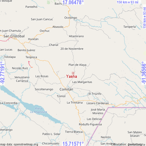
Yasha GPS coordinates[2]
16° 23' 29.076" North, 92° 4' 7.608" West
| Map corner | latitude | longitude |
|---|---|---|
| Upper-left | 17.06478°, | -92.77191° |
| Center: | 16.39141°, | -92.06878° |
| Lower-right: | 15.71571°, | -91.36566° |
| Map W x H: | 150×150 km | = 93.2×93.2mi |
| max Lat: | 32.7° ⇑95% North |
| Yasha: | 16.39141° |
| min Lat: | ⇓5% South 14.53588° |
| min Long | Yasha | max Long |
| -117.105° | -92.06878° | -86.73105° |
| W 95%⇐ | ⇒5% E |
Elevation
Elevation of Yasha is 1749 m = 5738 ft, and this is 495.3 m = 1625 ft above average elevation for this country.
| Max E: |
3497 m = 11473 ft | 38.6% |
| Yasha | 1749 m 5738 ft | |
| Avg. | 1253.7 m = 4113 ft | |
Min E: |
-1 m = -3 ft | 61.4% |
See also: Mexico elevation on elevation.city.
Geographical zone
Yasha is located in North Torrid zone (between Equator and Tropic of Cancer). Distance of this Northern Tropic circle is 783.4 km =486.8 mi to North.| Distance of | km | miles | from Yasha |
|---|---|---|---|
| North Pole | 8184.5 | 5085.6 | to North |
| Arctic Circle | 5578.6 | 3466.4 | to North |
| Tropic Cancer | 783.4 | 486.8 | to North |
| Equator | 1822.6 | 1132.5 | to South |


Nearby cities:
15 places around Yasha: (largest is in red/bold)
• Bajucu
9.3 km =5.8 mi,  2°
2°
• Jalisco
10.9 km =6.8 mi,  66°
66°
• Juznajab la Laguna
3.7 km =2.3 mi,  252°
252°
• Lomantán
5.4 km =3.4 mi, 4°
• Los Riegos
11.3 km =7 mi,  211°
211°
• Plan de Ayala
9.9 km =6.2 mi,  26°
26°
• Rosario Bawitz
11.9 km =7.4 mi,  343°
343°
• San Isidro Tinajab
12.3 km =7.6 mi,  200°
200°
• San José las Palmas
8.6 km =5.3 mi,  137°
137°
• San Rafael Jocom
12.2 km =7.6 mi, 210°
• Santo Domingo de las Granadas
10.7 km =6.6 mi, 208°
• Señor del Pozo
11.5 km =7.1 mi, 203°
• Veracruz
7.5 km =4.7 mi,  79°
79°
• Villahermosa Yaluma
6.5 km =4 mi,  188°
188°
• Yalcoc
10.2 km =6.3 mi,  124°
124°
Sources, notices
• [Note1] Compared only with cities in Mexico existing in our database
• [Src1] Map data: © OpenStreetMap contributors (CC-BY-SA)
• [Src2] Other city data from geonames.org with taken over terms of usage.
• [Src3] Geographical zone / Annual Mean Temperature by Robert A. Rohde @ Wikipedia
