Cajcam geodata
Cajcam (Chiapas) is a populated place; located in Mexico in America/Mexico_City (GMT-6) time zone. With population of 533 people, there are 15888 cities with bigger population in this country. Compared to other cities in Mexico, 95.9% of cities are located further ↑North; 95.1% of cities are located further ←West and 55.6% of cities have lower elevation than Cajcam. Note1


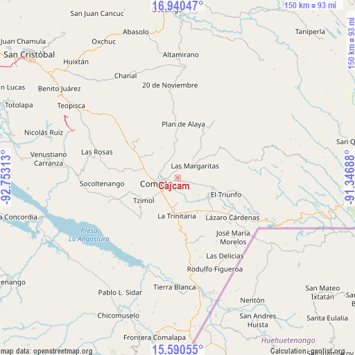
Cajcam GPS coordinates[2]
16° 16' 0.012" North, 92° 3' 0" West
| Map corner | latitude | longitude |
|---|---|---|
| Upper-left | 16.94047°, | -92.75313° |
| Center: | 16.26667°, | -92.05° |
| Lower-right: | 15.59055°, | -91.34688° |
| Map W x H: | 150.1×150.1 km | = 93.3×93.3mi |
| max Lat: | 32.7° ⇑95.9% North |
| Cajcam: | 16.26667° |
| min Lat: | ⇓4.1% South 14.53588° |
| min Long | Cajcam | max Long |
| -117.105° | -92.05° | -86.73105° |
| W 95.1%⇐ | ⇒4.9% E |
Elevation
Elevation of Cajcam is 1605 m = 5266 ft, and this is 351.3 m = 1153 ft above average elevation for this country.
| Max E: |
3497 m = 11473 ft | 44.4% |
| Cajcam | 1605 m 5266 ft | |
| Avg. | 1253.7 m = 4113 ft | |
Min E: |
-1 m = -3 ft | 55.6% |
See also: Mexico elevation on elevation.city.
Geographical zone
Cajcam is located in North Torrid zone (between Equator and Tropic of Cancer). Distance of this Northern Tropic circle is 797.2 km =495.4 mi to North.| Distance of | km | miles | from Cajcam |
|---|---|---|---|
| North Pole | 8198.4 | 5094.2 | to North |
| Arctic Circle | 5592.5 | 3475 | to North |
| Tropic Cancer | 797.2 | 495.4 | to North |
| Equator | 1808.7 | 1123.9 | to South |


Nearby cities:
15 places around Cajcam: (largest is in red/bold)
• Buenavista
7.2 km =4.5 mi,  111°
111°
• Cash
5.1 km =3.2 mi,  266°
266°
• El Rosario
7.8 km =4.8 mi,  132°
132°
• Galeana
7 km =4.3 mi, 131°
• Guadalupe Quistaj
6.1 km =3.8 mi,  163°
163°
• La Independencia
3.2 km =2 mi,  119°
119°
• Primero de Mayo
2.8 km =1.7 mi,  47°
47°
• Quistajito
5.8 km =3.6 mi, 131°
• Río Grande
8.1 km =5 mi,  280°
280°
• San Isidro Tinajab
6.8 km =4.2 mi,  290°
290°
• San José Yocnajab
4.2 km =2.6 mi,  250°
250°
• San José las Palmas
8.4 km =5.2 mi,  26°
26°
• San Miguel Tinajab
5.9 km =3.7 mi, 286°
• Señor del Pozo
7.4 km =4.6 mi,  296°
296°
• Villahermosa Yaluma
8 km =5 mi,  338°
338°
Sources, notices
• [Note1] Compared only with cities in Mexico existing in our database
• [Src1] Map data: © OpenStreetMap contributors (CC-BY-SA)
• [Src2] Other city data from geonames.org with taken over terms of usage.
• [Src3] Geographical zone / Annual Mean Temperature by Robert A. Rohde @ Wikipedia
