Veracruz geodata
Veracruz (Chiapas) is a populated place; located in Mexico in America/Mexico_City (GMT-6) time zone. With population of 1,062 people, there are 8219 cities with bigger population in this country. Compared to other cities in Mexico, 94.9% of cities are located further ↑North; 95.3% of cities are located further ←West and 53.9% of cities have lower elevation than Veracruz. Note1


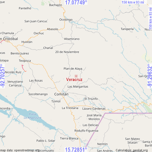
Veracruz GPS coordinates[2]
16° 24' 15.012" North, 91° 59' 57.984" West
| Map corner | latitude | longitude |
|---|---|---|
| Upper-left | 17.07749°, | -92.70257° |
| Center: | 16.40417°, | -91.99944° |
| Lower-right: | 15.72851°, | -91.29632° |
| Map W x H: | 150×150 km | = 93.2×93.2mi |
| max Lat: | 32.7° ⇑94.9% North |
| Veracruz: | 16.40417° |
| min Lat: | ⇓5.1% South 14.53588° |
| min Long | Veracruz | max Long |
| -117.105° | -91.99944° | -86.73105° |
| W 95.3%⇐ | ⇒4.7% E |
Elevation
Elevation of Veracruz is 1559 m = 5115 ft, and this is 305.3 m = 1002 ft above average elevation for this country.
| Max E: |
3497 m = 11473 ft | 46.1% |
| Veracruz | 1559 m 5115 ft | |
| Avg. | 1253.7 m = 4113 ft | |
Min E: |
-1 m = -3 ft | 53.9% |
See also: Mexico elevation on elevation.city.
Geographical zone
Veracruz is located in North Torrid zone (between Equator and Tropic of Cancer). Distance of this Northern Tropic circle is 781.9 km =485.8 mi to North.| Distance of | km | miles | from Veracruz |
|---|---|---|---|
| North Pole | 8183.1 | 5084.7 | to North |
| Arctic Circle | 5577.2 | 3465.5 | to North |
| Tropic Cancer | 781.9 | 485.8 | to North |
| Equator | 1824 | 1133.4 | to South |


Nearby cities:
15 places around Veracruz: (largest is in red/bold)
• Bajucu
10.5 km =6.5 mi,  318°
318°
• El Encanto
8.9 km =5.5 mi,  143°
143°
• Espíritu Santo
8.7 km =5.4 mi,  158°
158°
• Gabino Vázquez San Sebastián
8.9 km =5.5 mi,  131°
131°
• Ignacio Zaragoza
10.3 km =6.4 mi,  123°
123°
• Jalisco
3.9 km =2.4 mi,  41°
41°
• Las Margaritas
10.4 km =6.5 mi,  169°
169°
• Lomantán
8 km =5 mi,  299°
299°
• Mexiquito
7.9 km =4.9 mi,  26°
26°
• Plan de Ayala
8.1 km =5 mi,  338°
338°
• Rafael Ramírez
8.6 km =5.3 mi, 41°
• Saltillo
5.5 km =3.4 mi,  102°
102°
• San José las Palmas
7.9 km =4.9 mi,  191°
191°
• Yalcoc
7.2 km =4.5 mi, 171°
• Yasha
7.5 km =4.7 mi,  259°
259°
Sources, notices
• [Note1] Compared only with cities in Mexico existing in our database
• [Src1] Map data: © OpenStreetMap contributors (CC-BY-SA)
• [Src2] Other city data from geonames.org with taken over terms of usage.
• [Src3] Geographical zone / Annual Mean Temperature by Robert A. Rohde @ Wikipedia
