Vicente Guerrero geodata
Vicente Guerrero (Chiapas) is a populated place; located in Mexico in America/Mexico_City (GMT-6) time zone. With population of 1,997 people, there are 4359 cities with bigger population in this country. Compared to other cities in Mexico, 94.8% of cities are located further ↑North; 90.4% of cities are located further ←West and 68.6% of cities have higher elevation than Vicente Guerrero. Note1


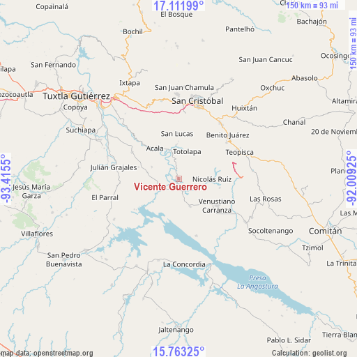
Vicente Guerrero GPS coordinates[2]
16° 26' 19.644" North, 92° 42' 44.532" West
| Map corner | latitude | longitude |
|---|---|---|
| Upper-left | 17.11199°, | -93.4155° |
| Center: | 16.43879°, | -92.71237° |
| Lower-right: | 15.76325°, | -92.00925° |
| Map W x H: | 150×150 km | = 93.2×93.2mi |
| max Lat: | 32.7° ⇑94.8% North |
| Vicente Guerrero: | 16.43879° |
| min Lat: | ⇓5.2% South 14.53588° |
| min Long | Vicente Guerrer | max Long |
| -117.105° | -92.71237° | -86.73105° |
| W 90.4%⇐ | ⇒9.6% E |
Elevation
Elevation of Vicente Guerrero is 491 m = 1611 ft, and this is 762.7 m = 2502 ft below average elevation for this country.
| Max E: |
3497 m = 11473 ft | 68.6% |
| Avg. | 1253.7 m = 4113 ft | |
| Vicente Guerrero | 491 m = 1611 ft | |
Min E: |
-1 m = -3 ft | 31.4% |
See also: Mexico elevation on elevation.city.
Geographical zone
Vicente Guerrero is located in North Torrid zone (between Equator and Tropic of Cancer). Distance of this Northern Tropic circle is 778.1 km =483.5 mi to North.| Distance of | km | miles | from Vicente Guerrero |
|---|---|---|---|
| North Pole | 8179.2 | 5082.3 | to North |
| Arctic Circle | 5573.4 | 3463.1 | to North |
| Tropic Cancer | 778.1 | 483.5 | to North |
| Equator | 1827.8 | 1135.7 | to South |


Nearby cities:
15 places around Vicente Guerrero: (largest is in red/bold)
• Acala
16.3 km =10.1 mi,  323°
323°
• Belisario Domínguez
6.6 km =4.1 mi,  235°
235°
• Chiapilla
14.6 km =9.1 mi,  356°
356°
• Francisco Villa
17.4 km =10.8 mi,  12°
12°
• Luis Echeverría Álvarez
8.9 km =5.5 mi,  256°
256°
• Lázaro Cárdenas
13.8 km =8.6 mi,  336°
336°
• Mariano Matamoros
14.4 km =8.9 mi,  70°
70°
• Miguel Hidalgo
13.3 km =8.3 mi,  137°
137°
• Nicolás Ruiz
13.6 km =8.5 mi,  90°
90°
• Nuevo León
15.9 km =9.9 mi, 70°
• Ponciano Arriaga
10.7 km =6.6 mi,  59°
59°
• Presidente Echeverría (Laja Tendida)
12.4 km =7.7 mi,  157°
157°
• Ricardo Flores Magón
5.3 km =3.3 mi, 160°
• Totolapa
12.1 km =7.5 mi,  16°
16°
• Unión Buena Vista
12.4 km =7.7 mi,  294°
294°
Sources, notices
• [Note1] Compared only with cities in Mexico existing in our database
• [Src1] Map data: © OpenStreetMap contributors (CC-BY-SA)
• [Src2] Other city data from geonames.org with taken over terms of usage.
• [Src3] Geographical zone / Annual Mean Temperature by Robert A. Rohde @ Wikipedia
