Miguel Hidalgo geodata
Miguel Hidalgo (Chiapas) is a populated place; located in Mexico in America/Mexico_City (GMT-6) time zone. With population of 1,178 people, there are 7369 cities with bigger population in this country. Compared to other cities in Mexico, 95.3% of cities are located further ↑North; 90.9% of cities are located further ←West and 66.8% of cities have higher elevation than Miguel Hidalgo. Note1


Miguel Hidalgo GPS coordinates[2]
16° 21' 2.16" North, 92° 37' 42.672" West
| Map corner | latitude | longitude |
|---|---|---|
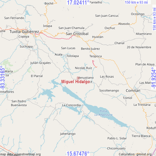
| Upper-left | 17.02411°, | -93.33165° |
| Center: | 16.3506°, | -92.62852° |
| Lower-right: | 15.67476°, | -91.9254° |
| Map W x H: | 150×150 km | = 93.2×93.2mi |
| max Lat: | 32.7° ⇑95.3% North |
| Miguel Hidalgo: | 16.3506° |
| min Lat: | ⇓4.7% South 14.53588° |
| min Long | Miguel Hidalgo | max Long |
| -117.105° | -92.62852° | -86.73105° |
| W 90.9%⇐ | ⇒9.1% E |
Elevation
Elevation of Miguel Hidalgo is 595 m = 1952 ft, and this is 658.7 m = 2161 ft below average elevation for this country.
| Max E: |
3497 m = 11473 ft | 66.8% |
| Avg. | 1253.7 m = 4113 ft | |
| Miguel Hidalgo | 595 m = 1952 ft | |
Min E: |
-1 m = -3 ft | 33.2% |
See also: Mexico elevation on elevation.city.
Geographical zone
Miguel Hidalgo is located in North Torrid zone (between Equator and Tropic of Cancer). Distance of this Northern Tropic circle is 787.9 km =489.6 mi to North.| Distance of | km | miles | from Miguel Hidalgo |
|---|---|---|---|
| North Pole | 8189 | 5088.4 | to North |
| Arctic Circle | 5583.2 | 3469.2 | to North |
| Tropic Cancer | 787.9 | 489.6 | to North |
| Equator | 1818 | 1129.7 | to South |


Nearby cities:
15 places around Miguel Hidalgo: (largest is in red/bold)
• Belisario Domínguez
15.6 km =9.7 mi,  293°
293°
• Grandeza del Río Blanco
14.1 km =8.8 mi,  74°
74°
• Guadalupe Victoria
10.1 km =6.3 mi,  53°
53°
• La Gloria (La Tranca)
17.8 km =11.1 mi,  107°
107°
• Luis Echeverría Álvarez
19.2 km =11.9 mi, 293°
• Mariano Matamoros
15.3 km =9.5 mi,  17°
17°
• Nicolás Ruiz
10.7 km =6.6 mi,  25°
25°
• Nuevo León
16.3 km =10.1 mi, 21°
• Paraíso del Grijalva
14 km =8.7 mi,  186°
186°
• Ponciano Arriaga
15.3 km =9.5 mi,  1°
1°
• Presidente Echeverría (Laja Tendida)
4.6 km =2.9 mi,  248°
248°
• Ricardo Flores Magón
8.7 km =5.4 mi,  303°
303°
• San Francisco (El Calvito)
7.8 km =4.8 mi, 114°
• Venustiano Carranza
7.1 km =4.4 mi,  101°
101°
• Vicente Guerrero
13.3 km =8.3 mi,  317°
317°
Sources, notices
• [Note1] Compared only with cities in Mexico existing in our database
• [Src1] Map data: © OpenStreetMap contributors (CC-BY-SA)
• [Src2] Other city data from geonames.org with taken over terms of usage.
• [Src3] Geographical zone / Annual Mean Temperature by Robert A. Rohde @ Wikipedia
