Venustiano Carranza geodata
Venustiano Carranza (Chiapas) is a seat of a second-order administrative division; located in Mexico in America/Mexico_City (GMT-6) time zone. With population of 15,496 people, there are 617 cities with bigger population in this country. Compared to other cities in Mexico, 95.4% of cities are located further ↑North; 91.4% of cities are located further ←West and 63.6% of cities have higher elevation than Venustiano Carranza. Note1


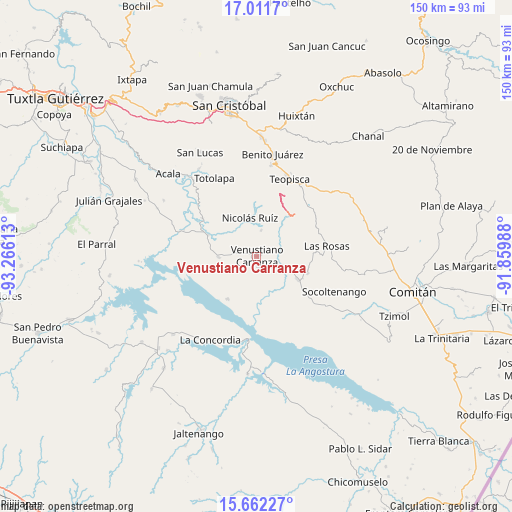
Venustiano Carranza GPS coordinates[2]
16° 20' 17.34" North, 92° 33' 46.8" West
| Map corner | latitude | longitude |
|---|---|---|
| Upper-left | 17.0117°, | -93.26613° |
| Center: | 16.33815°, | -92.563° |
| Lower-right: | 15.66227°, | -91.85988° |
| Map W x H: | 150×150 km | = 93.2×93.2mi |
| max Lat: | 32.7° ⇑95.4% North |
| Venustiano Carranza: | 16.33815° |
| min Lat: | ⇓4.6% South 14.53588° |
| min Long | Venustiano Carr | max Long |
| -117.105° | -92.563° | -86.73105° |
| W 91.4%⇐ | ⇒8.6% E |
Elevation
Elevation of Venustiano Carranza is 775 m = 2543 ft, and this is 478.7 m = 1571 ft below average elevation for this country.
| Max E: |
3497 m = 11473 ft | 63.6% |
| Avg. | 1253.7 m = 4113 ft | |
| Venustiano Carranza | 775 m = 2543 ft | |
Min E: |
-1 m = -3 ft | 36.4% |
See also: Mexico elevation on elevation.city.
Geographical zone
Venustiano Carranza is located in North Torrid zone (between Equator and Tropic of Cancer). Distance of this Northern Tropic circle is 789.3 km =490.4 mi to North.| Distance of | km | miles | from Venustiano Carranza |
|---|---|---|---|
| North Pole | 8190.4 | 5089.3 | to North |
| Arctic Circle | 5584.5 | 3470 | to North |
| Tropic Cancer | 789.3 | 490.4 | to North |
| Equator | 1816.6 | 1128.8 | to South |


Nearby cities:
15 places around Venustiano Carranza: (largest is in red/bold)
• Corral Hierba
15 km =9.3 mi,  86°
86°
• Grandeza del Río Blanco
8.4 km =5.2 mi,  52°
52°
• Guadalupe Victoria
7.5 km =4.7 mi,  8°
8°
• Ixtapilla
14.4 km =8.9 mi,  78°
78°
• La Gloria (La Tranca)
10.8 km =6.7 mi,  110°
110°
• Mariano Matamoros
16.1 km =10 mi,  351°
351°
• Miguel Hidalgo
7.1 km =4.4 mi,  281°
281°
• Nicolás Ruiz
11.3 km =7 mi, 347°
• Nuevo León
16.5 km =10.3 mi,  356°
356°
• Paraíso del Grijalva
15.1 km =9.4 mi,  214°
214°
• Presidente Echeverría (Laja Tendida)
11.3 km =7 mi,  268°
268°
• Ricardo Flores Magón
15.5 km =9.6 mi,  293°
293°
• San Francisco (El Calvito)
1.8 km =1.1 mi,  176°
176°
• San Francisco Pujiltic
13.4 km =8.3 mi,  119°
119°
• Soyatitán
15.6 km =9.7 mi, 108°
Sources, notices
• [Note1] Compared only with cities in Mexico existing in our database
• [Src1] Map data: © OpenStreetMap contributors (CC-BY-SA)
• [Src2] Other city data from geonames.org with taken over terms of usage.
• [Src3] Geographical zone / Annual Mean Temperature by Robert A. Rohde @ Wikipedia
