Guadalupe Victoria geodata
Guadalupe Victoria (Chiapas) is a populated place; located in Mexico in America/Mexico_City (GMT-6) time zone. With population of 1,767 people, there are 4916 cities with bigger population in this country. Compared to other cities in Mexico, 94.9% of cities are located further ↑North; 91.5% of cities are located further ←West and 60.5% of cities have higher elevation than Guadalupe Victoria. Note1


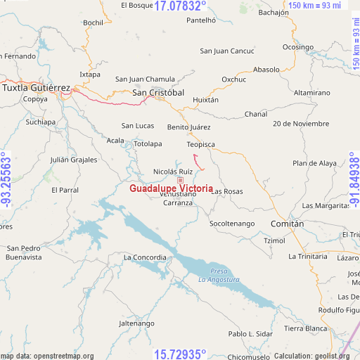
Guadalupe Victoria GPS coordinates[2]
16° 24' 18" North, 92° 33' 9" West
| Map corner | latitude | longitude |
|---|---|---|
| Upper-left | 17.07832°, | -93.25563° |
| Center: | 16.405°, | -92.5525° |
| Lower-right: | 15.72935°, | -91.84938° |
| Map W x H: | 150×150 km | = 93.2×93.2mi |
| max Lat: | 32.7° ⇑94.9% North |
| Guadalupe Victoria: | 16.405° |
| min Lat: | ⇓5.1% South 14.53588° |
| min Long | Guadalupe Victo | max Long |
| -117.105° | -92.5525° | -86.73105° |
| W 91.5%⇐ | ⇒8.5% E |
Elevation
Elevation of Guadalupe Victoria is 967 m = 3173 ft, and this is 286.7 m = 941 ft below average elevation for this country.
| Max E: |
3497 m = 11473 ft | 60.5% |
| Avg. | 1253.7 m = 4113 ft | |
| Guadalupe Victoria | 967 m = 3173 ft | |
Min E: |
-1 m = -3 ft | 39.5% |
See also: Mexico elevation on elevation.city.
Geographical zone
Guadalupe Victoria is located in North Torrid zone (between Equator and Tropic of Cancer). Distance of this Northern Tropic circle is 781.9 km =485.8 mi to North.| Distance of | km | miles | from Guadalupe Victoria |
|---|---|---|---|
| North Pole | 8183 | 5084.7 | to North |
| Arctic Circle | 5577.1 | 3465.4 | to North |
| Tropic Cancer | 781.9 | 485.8 | to North |
| Equator | 1824.1 | 1133.4 | to South |


Nearby cities:
15 places around Guadalupe Victoria: (largest is in red/bold)
• Chijiltec (San Isidro)
17 km =10.6 mi,  8°
8°
• Corral Hierba
15.3 km =9.5 mi,  115°
115°
• El Puerto
13.2 km =8.2 mi,  79°
79°
• Grandeza del Río Blanco
6 km =3.7 mi,  112°
112°
• Ixtapilla
13.8 km =8.6 mi, 109°
• La Gloria (La Tranca)
14.4 km =8.9 mi,  141°
141°
• Mariano Matamoros
9.1 km =5.7 mi,  337°
337°
• Miguel Hidalgo
10.1 km =6.3 mi,  233°
233°
• Nicolás Ruiz
5 km =3.1 mi,  315°
315°
• Nuevo León
9.3 km =5.8 mi,  347°
347°
• Ponciano Arriaga
12.1 km =7.5 mi, 319°
• Presidente Echeverría (Laja Tendida)
14.6 km =9.1 mi,  238°
238°
• Ricardo Flores Magón
15.4 km =9.6 mi,  265°
265°
• San Francisco (El Calvito)
9.3 km =5.8 mi,  186°
186°
• Venustiano Carranza
7.5 km =4.7 mi, 188°
Sources, notices
• [Note1] Compared only with cities in Mexico existing in our database
• [Src1] Map data: © OpenStreetMap contributors (CC-BY-SA)
• [Src2] Other city data from geonames.org with taken over terms of usage.
• [Src3] Geographical zone / Annual Mean Temperature by Robert A. Rohde @ Wikipedia
