Monte Sinaí geodata
Monte Sinaí (Chiapas) is a populated place; located in Mexico in America/Mexico_City (GMT-6) time zone. With population of 549 people, there are 15509 cities with bigger population in this country. Compared to other cities in Mexico, 98.1% of cities are located further ↑North; 93% of cities are located further ←West and 54.2% of cities have higher elevation than Monte Sinaí. Note1


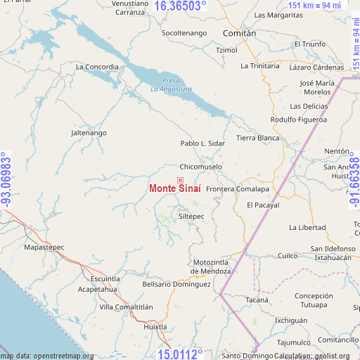
Monte Sinaí GPS coordinates[2]
15° 41' 21.264" North, 92° 22' 0.12" West
| Map corner | latitude | longitude |
|---|---|---|
| Upper-left | 16.36503°, | -93.06983° |
| Center: | 15.68924°, | -92.3667° |
| Lower-right: | 15.0112°, | -91.66358° |
| Map W x H: | 150.5×150.5 km | = 93.5×93.5mi |
| max Lat: | 32.7° ⇑98.1% North |
| Monte Sinaí: | 15.68924° |
| min Lat: | ⇓1.9% South 14.53588° |
| min Long | Monte Sinaí | max Long |
| -117.105° | -92.3667° | -86.73105° |
| W 93%⇐ | ⇒7% E |
Elevation
Elevation of Monte Sinaí is 1234 m = 4049 ft, and this is 19.7 m = 65 ft below average elevation for this country.
| Max E: |
3497 m = 11473 ft | 54.2% |
| Avg. | 1253.7 m = 4113 ft | |
| Monte Sinaí | 1234 m = 4049 ft | |
Min E: |
-1 m = -3 ft | 45.8% |
See also: Mexico elevation on elevation.city.
Geographical zone
Monte Sinaí is located in North Torrid zone (between Equator and Tropic of Cancer). Distance of this Northern Tropic circle is 861.4 km =535.2 mi to North.| Distance of | km | miles | from Monte Sinaí |
|---|---|---|---|
| North Pole | 8262.6 | 5134.1 | to North |
| Arctic Circle | 5656.7 | 3514.9 | to North |
| Tropic Cancer | 861.4 | 535.2 | to North |
| Equator | 1744.5 | 1084 | to South |


Nearby cities:
15 places around Monte Sinaí: (largest is in red/bold)
• 20 de Noviembre
5.6 km =3.5 mi,  346°
346°
• Chicomuselo
10.8 km =6.7 mi,  55°
55°
• Emiliano Zapata
13.9 km =8.6 mi,  99°
99°
• Grecia
13.5 km =8.4 mi,  340°
340°
• La Hacienda
10.1 km =6.3 mi,  115°
115°
• La Rinconada
15 km =9.3 mi,  135°
135°
• La Zacualpa
6.1 km =3.8 mi,  86°
86°
• Las Delicias
15.8 km =9.8 mi,  247°
247°
• Lázaro Cárdenas
12.4 km =7.7 mi,  75°
75°
• Miguel Alemán
14.4 km =8.9 mi,  288°
288°
• Nueva Morelia
11.7 km =7.3 mi,  311°
311°
• Nuevo Pacayal
6.4 km =4 mi, 120°
• Piedra Labrada
6.6 km =4.1 mi, 96°
• Pinada de Arriba
9.3 km =5.8 mi,  149°
149°
• Siltepec
15.4 km =9.6 mi,  162°
162°
Sources, notices
• [Note1] Compared only with cities in Mexico existing in our database
• [Src1] Map data: © OpenStreetMap contributors (CC-BY-SA)
• [Src2] Other city data from geonames.org with taken over terms of usage.
• [Src3] Geographical zone / Annual Mean Temperature by Robert A. Rohde @ Wikipedia
