Palmar de Guadalupe geodata
Palmar de Guadalupe (State of Mexico) is a populated place; located in Mexico in America/Mexico_City (GMT-6) time zone. With population of 635 people, there are 13639 cities with bigger population in this country. Compared to other cities in Mexico, 66.9% of cities are located further ↑North; 57.4% of cities are located further →East and 71.1% of cities have lower elevation than Palmar de Guadalupe. Note1


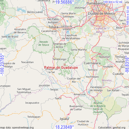
Palmar de Guadalupe GPS coordinates[2]
18° 54' 18" North, 99° 32' 4.992" West
| Map corner | latitude | longitude |
|---|---|---|
| Upper-left | 19.56886°, | -100.23785° |
| Center: | 18.905°, | -99.53472° |
| Lower-right: | 18.23849°, | -98.8316° |
| Map W x H: | 147.9×147.9 km | = 91.9×91.9mi |
| max Lat: | 32.7° ⇑66.9% North |
| Palmar de Guadalupe: | 18.905° |
| min Lat: | ⇓33.1% South 14.53588° |
| min Long | Palmar de Guada | max Long |
| -117.105° | -99.53472° | -86.73105° |
| W 42.6%⇐ | ⇒57.4% E |
Elevation
Elevation of Palmar de Guadalupe is 1948 m = 6391 ft, and this is 694.3 m = 2278 ft above average elevation for this country.
| Max E: |
3497 m = 11473 ft | 28.9% |
| Palmar de Guadalupe | 1948 m 6391 ft | |
| Avg. | 1253.7 m = 4113 ft | |
Min E: |
-1 m = -3 ft | 71.1% |
See also: Mexico elevation on elevation.city.
Geographical zone
Palmar de Guadalupe is located in North Torrid zone (between Equator and Tropic of Cancer). Distance of this Northern Tropic circle is 503.9 km =313.1 mi to North.| Distance of | km | miles | from Palmar de Guadalupe |
|---|---|---|---|
| North Pole | 7905 | 4911.9 | to North |
| Arctic Circle | 5299.1 | 3292.7 | to North |
| Tropic Cancer | 503.9 | 313.1 | to North |
| Equator | 2102 | 1306.1 | to South |


Nearby cities:
15 places around Palmar de Guadalupe: (largest is in red/bold)
• Acatzingo (Acatzingo de la Piedra)
6 km =3.7 mi,  290°
290°
• Colonia Emiliano Zapata Ejido de Tenancingo
6 km =3.7 mi,  334°
334°
• Ejido Ixpuchiapan
6.2 km =3.9 mi,  319°
319°
• El Carmen (El Desierto del Carmen)
2.9 km =1.8 mi,  306°
306°
• El Puentecito
6.6 km =4.1 mi,  79°
79°
• Ixpuichiapan
6.3 km =3.9 mi,  299°
299°
• Jalmolonga (La Hacienda)
4.5 km =2.8 mi,  70°
70°
• La Ladrillera
6 km =3.7 mi, 65°
• Malinalco
6.3 km =3.9 mi,  39°
39°
• San José Chalmita
5.4 km =3.4 mi,  195°
195°
• San José Tenería (Tenería)
5.1 km =3.2 mi,  350°
350°
• San Nicolás
4.7 km =2.9 mi, 311°
• Santa Catarina
5.7 km =3.5 mi,  245°
245°
• Terrenate
6.7 km =4.2 mi, 291°
• Zumpahuacán
3.5 km =2.2 mi, 291°
Sources, notices
• [Note1] Compared only with cities in Mexico existing in our database
• [Src1] Map data: © OpenStreetMap contributors (CC-BY-SA)
• [Src2] Other city data from geonames.org with taken over terms of usage.
• [Src3] Geographical zone / Annual Mean Temperature by Robert A. Rohde @ Wikipedia
