Tlatempa geodata
Tlatempa (Puebla) is a populated place; located in Mexico in America/Mexico_City (GMT-6) time zone. With population of 2,189 people, there are 4016 cities with bigger population in this country. Compared to other cities in Mexico, 55.9% of cities are located further ↓South; 64.4% of cities are located further ←West and 76.1% of cities have lower elevation than Tlatempa. Note1


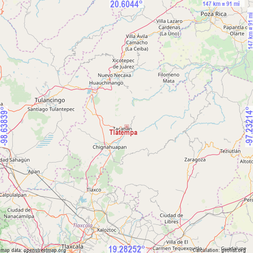
Tlatempa GPS coordinates[2]
19° 56' 41.424" North, 97° 56' 6.936" West
| Map corner | latitude | longitude |
|---|---|---|
| Upper-left | 20.6044°, | -98.63839° |
| Center: | 19.94484°, | -97.93526° |
| Lower-right: | 19.28252°, | -97.23214° |
| Map W x H: | 147×147 km | = 91.3×91.3mi |
| max Lat: | 32.7° ⇑44.1% North |
| Tlatempa: | 19.94484° |
| min Lat: | ⇓55.9% South 14.53588° |
| min Long | Tlatempa | max Long |
| -117.105° | -97.93526° | -86.73105° |
| W 64.4%⇐ | ⇒35.6% E |
Elevation
Elevation of Tlatempa is 2050 m = 6726 ft, and this is 796.3 m = 2613 ft above average elevation for this country.
| Max E: |
3497 m = 11473 ft | 23.9% |
| Tlatempa | 2050 m 6726 ft | |
| Avg. | 1253.7 m = 4113 ft | |
Min E: |
-1 m = -3 ft | 76.1% |
See also: Mexico elevation on elevation.city.
Geographical zone
Tlatempa is located in North Torrid zone (between Equator and Tropic of Cancer). Distance of this Northern Tropic circle is 388.3 km =241.3 mi to North.| Distance of | km | miles | from Tlatempa |
|---|---|---|---|
| North Pole | 7789.4 | 4840.1 | to North |
| Arctic Circle | 5183.5 | 3220.9 | to North |
| Tropic Cancer | 388.3 | 241.3 | to North |
| Equator | 2217.7 | 1378 | to South |


Nearby cities:
15 places around Tlatempa: (largest is in red/bold)
• Atzingo (La Cumbre)
5.2 km =3.2 mi,  318°
318°
• Jicolapa
4.6 km =2.9 mi,  300°
300°
• Maquixtla
5.2 km =3.2 mi,  253°
253°
• Poxcuatzingo
4.8 km =3 mi,  288°
288°
• San Jerónimo Coaltepec
9.7 km =6 mi,  47°
47°
• San Miguel Tenango
4 km =2.5 mi,  179°
179°
• San Pedro Atmatla
5.1 km =3.2 mi,  221°
221°
• Tenantitla
5 km =3.1 mi,  100°
100°
• Tepoxcuautla
8.5 km =5.3 mi,  237°
237°
• Tlaquimpa
6.1 km =3.8 mi,  70°
70°
• Tomatlán
6.9 km =4.3 mi, 215°
• Xochitlaxco (San Baltazar)
7.5 km =4.7 mi,  92°
92°
• Xonotla
4.2 km =2.6 mi,  125°
125°
• Xoxonacatla
7 km =4.3 mi,  355°
355°
• Zacatlán
2.9 km =1.8 mi, 249°
Sources, notices
• [Note1] Compared only with cities in Mexico existing in our database
• [Src1] Map data: © OpenStreetMap contributors (CC-BY-SA)
• [Src2] Other city data from geonames.org with taken over terms of usage.
• [Src3] Geographical zone / Annual Mean Temperature by Robert A. Rohde @ Wikipedia
