Tenantitla geodata
Tenantitla (Puebla) is a populated place; located in Mexico in America/Mexico_City (GMT-6) time zone. With population of 929 people, there are 9387 cities with bigger population in this country. Compared to other cities in Mexico, 55.7% of cities are located further ↓South; 65% of cities are located further ←West and 89.6% of cities have lower elevation than Tenantitla. Note1


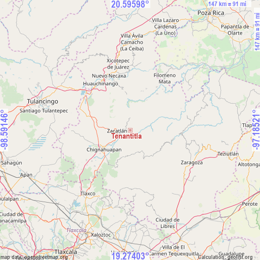
Tenantitla GPS coordinates[2]
19° 56' 11.004" North, 97° 53' 17.988" West
| Map corner | latitude | longitude |
|---|---|---|
| Upper-left | 20.59598°, | -98.59146° |
| Center: | 19.93639°, | -97.88833° |
| Lower-right: | 19.27403°, | -97.18521° |
| Map W x H: | 147×147 km | = 91.3×91.3mi |
| max Lat: | 32.7° ⇑44.3% North |
| Tenantitla: | 19.93639° |
| min Lat: | ⇓55.7% South 14.53588° |
| min Long | Tenantitla | max Long |
| -117.105° | -97.88833° | -86.73105° |
| W 65%⇐ | ⇒35% E |
Elevation
Elevation of Tenantitla is 2392 m = 7848 ft, and this is 1138.3 m = 3735 ft above average elevation for this country.
| Max E: |
3497 m = 11473 ft | 10.4% |
| Tenantitla | 2392 m 7848 ft | |
| Avg. | 1253.7 m = 4113 ft | |
Min E: |
-1 m = -3 ft | 89.6% |
See also: Mexico elevation on elevation.city.
Geographical zone
Tenantitla is located in North Torrid zone (between Equator and Tropic of Cancer). Distance of this Northern Tropic circle is 389.2 km =241.8 mi to North.| Distance of | km | miles | from Tenantitla |
|---|---|---|---|
| North Pole | 7790.3 | 4840.7 | to North |
| Arctic Circle | 5184.5 | 3221.5 | to North |
| Tropic Cancer | 389.2 | 241.8 | to North |
| Equator | 2216.7 | 1377.4 | to South |


Nearby cities:
15 places around Tenantitla: (largest is in red/bold)
• Chicometepec (San Simón)
6.9 km =4.3 mi,  65°
65°
• Ixtolco de Morelos
8.1 km =5 mi,  114°
114°
• Pochálcatl
8.2 km =5.1 mi,  25°
25°
• San Jerónimo Coaltepec
7.8 km =4.8 mi,  16°
16°
• San Miguel Tenango
5.7 km =3.5 mi,  237°
237°
• Tepetzintla
6 km =3.7 mi,  55°
55°
• Tlamanca de Hernández
8 km =5 mi, 74°
• Tlaquimpa
3 km =1.9 mi, 15°
• Tlatempa
5 km =3.1 mi,  280°
280°
• Tonalixco
7.1 km =4.4 mi,  45°
45°
• Totomoxtla
8.2 km =5.1 mi,  91°
91°
• Xaltatempa de Lucas
7.8 km =4.8 mi,  145°
145°
• Xochitlaxco (San Baltazar)
2.6 km =1.6 mi,  77°
77°
• Xonotla
2.1 km =1.3 mi,  224°
224°
• Zacatlán
7.6 km =4.7 mi,  269°
269°
Sources, notices
• [Note1] Compared only with cities in Mexico existing in our database
• [Src1] Map data: © OpenStreetMap contributors (CC-BY-SA)
• [Src2] Other city data from geonames.org with taken over terms of usage.
• [Src3] Geographical zone / Annual Mean Temperature by Robert A. Rohde @ Wikipedia
