Atzingo (La Cumbre) geodata
Atzingo (La Cumbre) (Puebla) is a populated place; located in Mexico in America/Mexico_City (GMT-6) time zone. With population of 3,336 people, there are 2726 cities with bigger population in this country. Compared to other cities in Mexico, 56.6% of cities are located further ↓South; 64% of cities are located further ←West and 80.5% of cities have lower elevation than Atzingo (La Cumbre). Note1


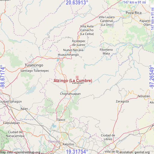
Atzingo (La Cumbre) GPS coordinates[2]
19° 58' 46.992" North, 97° 58' 6.996" West
| Map corner | latitude | longitude |
|---|---|---|
| Upper-left | 20.63913°, | -98.67174° |
| Center: | 19.97972°, | -97.96861° |
| Lower-right: | 19.31754°, | -97.26549° |
| Map W x H: | 146.9×146.9 km | = 91.3×91.3mi |
| max Lat: | 32.7° ⇑43.4% North |
| Atzingo (La Cumbre): | 19.97972° |
| min Lat: | ⇓56.6% South 14.53588° |
| min Long | Atzingo (La Cum | max Long |
| -117.105° | -97.96861° | -86.73105° |
| W 64%⇐ | ⇒36% E |
Elevation
Elevation of Atzingo (La Cumbre) is 2154 m = 7067 ft, and this is 900.3 m = 2954 ft above average elevation for this country.
| Max E: |
3497 m = 11473 ft | 19.5% |
| Atzingo (La Cumbre) | 2154 m 7067 ft | |
| Avg. | 1253.7 m = 4113 ft | |
Min E: |
-1 m = -3 ft | 80.5% |
See also: Mexico elevation on elevation.city.
Geographical zone
Atzingo (La Cumbre) is located in North Torrid zone (between Equator and Tropic of Cancer). Distance of this Northern Tropic circle is 384.4 km =238.9 mi to North.| Distance of | km | miles | from Atzingo (La Cumbre) |
|---|---|---|---|
| North Pole | 7785.5 | 4837.7 | to North |
| Arctic Circle | 5179.6 | 3218.5 | to North |
| Tropic Cancer | 384.4 | 238.9 | to North |
| Equator | 2221.5 | 1380.4 | to South |


Nearby cities:
15 places around Atzingo (La Cumbre): (largest is in red/bold)
• Jicolapa
1.6 km =1 mi,  198°
198°
• Jilotzingo
9.1 km =5.7 mi,  49°
49°
• Maquixtla
5.5 km =3.4 mi, 195°
• Matlahuacala
7.7 km =4.8 mi,  240°
240°
• Poxcuatzingo
2.6 km =1.6 mi, 203°
• San Miguel Tenango
8.6 km =5.3 mi,  155°
155°
• San Pedro Atmatla
7.7 km =4.8 mi,  179°
179°
• Tepexco
5.6 km =3.5 mi,  11°
11°
• Tepoxcuautla
9.2 km =5.7 mi, 203°
• Tlaquimpa
9.4 km =5.8 mi,  101°
101°
• Tlatempa
5.2 km =3.2 mi,  138°
138°
• Tlaxco (Santiago Tlaxco)
8.7 km =5.4 mi,  4°
4°
• Xonotla
9.4 km =5.8 mi,  132°
132°
• Xoxonacatla
4.3 km =2.7 mi,  43°
43°
• Zacatlán
5 km =3.1 mi,  171°
171°
Sources, notices
• [Note1] Compared only with cities in Mexico existing in our database
• [Src1] Map data: © OpenStreetMap contributors (CC-BY-SA)
• [Src2] Other city data from geonames.org with taken over terms of usage.
• [Src3] Geographical zone / Annual Mean Temperature by Robert A. Rohde @ Wikipedia
