Xoxonacatla geodata
Xoxonacatla (Puebla) is a populated place; located in Mexico in America/Mexico_City (GMT-6) time zone. With population of 2,007 people, there are 4337 cities with bigger population in this country. Compared to other cities in Mexico, 57.1% of cities are located further ↓South; 64.3% of cities are located further ←West and 73.9% of cities have lower elevation than Xoxonacatla. Note1


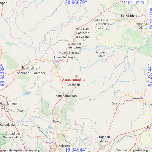
Xoxonacatla GPS coordinates[2]
20° 0' 27" North, 97° 56' 26.016" West
| Map corner | latitude | longitude |
|---|---|---|
| Upper-left | 20.66679°, | -98.64369° |
| Center: | 20.0075°, | -97.94056° |
| Lower-right: | 19.34544°, | -97.23744° |
| Map W x H: | 146.9×146.9 km | = 91.3×91.3mi |
| max Lat: | 32.7° ⇑42.9% North |
| Xoxonacatla: | 20.0075° |
| min Lat: | ⇓57.1% South 14.53588° |
| min Long | Xoxonacatla | max Long |
| -117.105° | -97.94056° | -86.73105° |
| W 64.3%⇐ | ⇒35.7% E |
Elevation
Elevation of Xoxonacatla is 2009 m = 6591 ft, and this is 755.3 m = 2478 ft above average elevation for this country.
| Max E: |
3497 m = 11473 ft | 26.1% |
| Xoxonacatla | 2009 m 6591 ft | |
| Avg. | 1253.7 m = 4113 ft | |
Min E: |
-1 m = -3 ft | 73.9% |
See also: Mexico elevation on elevation.city.
Geographical zone
Xoxonacatla is located in North Torrid zone (between Equator and Tropic of Cancer). Distance of this Northern Tropic circle is 381.3 km =236.9 mi to North.| Distance of | km | miles | from Xoxonacatla |
|---|---|---|---|
| North Pole | 7782.4 | 4835.8 | to North |
| Arctic Circle | 5176.5 | 3216.5 | to North |
| Tropic Cancer | 381.3 | 236.9 | to North |
| Equator | 2224.6 | 1382.3 | to South |


Nearby cities:
15 places around Xoxonacatla: (largest is in red/bold)
• Atzingo (La Cumbre)
4.3 km =2.7 mi,  223°
223°
• Cuetzalingo
7.2 km =4.5 mi,  15°
15°
• Jicolapa
5.8 km =3.6 mi, 216°
• Jilotzingo
4.9 km =3 mi,  55°
55°
• Poxcuatzingo
6.7 km =4.2 mi, 215°
• San Cristóbal Xochimilpa
7.4 km =4.6 mi,  27°
27°
• San Jerónimo Coaltepec
7.8 km =4.8 mi,  92°
92°
• San Marcos Eloxochitlán
7.4 km =4.6 mi,  74°
74°
• Tepexco
3 km =1.9 mi,  322°
322°
• Tlaquimpa
8 km =5 mi,  128°
128°
• Tlatempa
7 km =4.3 mi,  175°
175°
• Tlaxco (Santiago Tlaxco)
6.1 km =3.8 mi,  337°
337°
• Toxtla
6.6 km =4.1 mi,  353°
353°
• Xochicuautla
7.4 km =4.6 mi,  46°
46°
• Zacatlán
8.3 km =5.2 mi,  195°
195°
Sources, notices
• [Note1] Compared only with cities in Mexico existing in our database
• [Src1] Map data: © OpenStreetMap contributors (CC-BY-SA)
• [Src2] Other city data from geonames.org with taken over terms of usage.
• [Src3] Geographical zone / Annual Mean Temperature by Robert A. Rohde @ Wikipedia
