Jicolapa geodata
Jicolapa (Puebla) is a populated place; located in Mexico in America/Mexico_City (GMT-6) time zone. With population of 3,151 people, there are 2868 cities with bigger population in this country. Compared to other cities in Mexico, 56.3% of cities are located further ↓South; 63.9% of cities are located further ←West and 79.1% of cities have lower elevation than Jicolapa. Note1


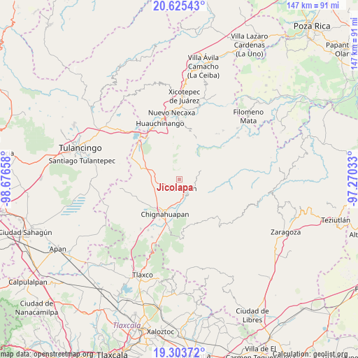
Jicolapa GPS coordinates[2]
19° 57' 57.456" North, 97° 58' 24.42" West
| Map corner | latitude | longitude |
|---|---|---|
| Upper-left | 20.62543°, | -98.67658° |
| Center: | 19.96596°, | -97.97345° |
| Lower-right: | 19.30372°, | -97.27033° |
| Map W x H: | 147×147 km | = 91.3×91.3mi |
| max Lat: | 32.7° ⇑43.7% North |
| Jicolapa: | 19.96596° |
| min Lat: | ⇓56.3% South 14.53588° |
| min Long | Jicolapa | max Long |
| -117.105° | -97.97345° | -86.73105° |
| W 63.9%⇐ | ⇒36.1% E |
Elevation
Elevation of Jicolapa is 2120 m = 6955 ft, and this is 866.3 m = 2842 ft above average elevation for this country.
| Max E: |
3497 m = 11473 ft | 20.9% |
| Jicolapa | 2120 m 6955 ft | |
| Avg. | 1253.7 m = 4113 ft | |
Min E: |
-1 m = -3 ft | 79.1% |
See also: Mexico elevation on elevation.city.
Geographical zone
Jicolapa is located in North Torrid zone (between Equator and Tropic of Cancer). Distance of this Northern Tropic circle is 385.9 km =239.8 mi to North.| Distance of | km | miles | from Jicolapa |
|---|---|---|---|
| North Pole | 7787.1 | 4838.7 | to North |
| Arctic Circle | 5181.2 | 3219.4 | to North |
| Tropic Cancer | 385.9 | 239.8 | to North |
| Equator | 2220 | 1379.4 | to South |


Nearby cities:
15 places around Jicolapa: (largest is in red/bold)
• Atzingo (La Cumbre)
1.6 km =1 mi,  18°
18°
• Ayotla
8.6 km =5.3 mi,  233°
233°
• Maquixtla
3.9 km =2.4 mi,  193°
193°
• Matlahuacala
6.6 km =4.1 mi,  250°
250°
• Metepec
9.1 km =5.7 mi,  283°
283°
• Poxcuatzingo
1 km =0.6 mi,  211°
211°
• San Miguel Tenango
7.5 km =4.7 mi,  147°
147°
• San Pedro Atmatla
6.2 km =3.9 mi,  174°
174°
• Tepexco
7.2 km =4.5 mi,  12°
12°
• Tepoxcuautla
7.6 km =4.7 mi,  204°
204°
• Tlatempa
4.6 km =2.9 mi,  120°
120°
• Tomatlán
8 km =5 mi,  180°
180°
• Xonotla
8.8 km =5.5 mi, 122°
• Xoxonacatla
5.8 km =3.6 mi,  36°
36°
• Zacatlán
3.6 km =2.2 mi,  159°
159°
Sources, notices
• [Note1] Compared only with cities in Mexico existing in our database
• [Src1] Map data: © OpenStreetMap contributors (CC-BY-SA)
• [Src2] Other city data from geonames.org with taken over terms of usage.
• [Src3] Geographical zone / Annual Mean Temperature by Robert A. Rohde @ Wikipedia
