Tepetzitzintla geodata
Tepetzitzintla (Puebla) is a populated place; located in Mexico in America/Mexico_City (GMT-6) time zone. With population of 1,453 people, there are 5939 cities with bigger population in this country. Compared to other cities in Mexico, 70.4% of cities are located further ↑North; 62.7% of cities are located further ←West and 55.1% of cities have lower elevation than Tepetzitzintla. Note1


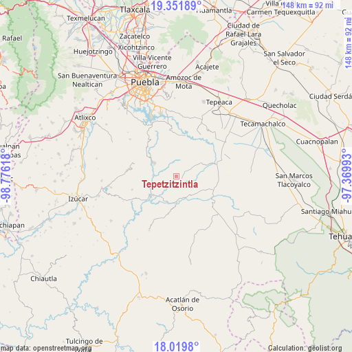
Tepetzitzintla GPS coordinates[2]
18° 41' 13.74" North, 98° 4' 22.98" West
| Map corner | latitude | longitude |
|---|---|---|
| Upper-left | 19.35189°, | -98.77618° |
| Center: | 18.68715°, | -98.07305° |
| Lower-right: | 18.0198°, | -97.36993° |
| Map W x H: | 148.1×148.1 km | = 92×92mi |
| max Lat: | 32.7° ⇑70.4% North |
| Tepetzitzintla: | 18.68715° |
| min Lat: | ⇓29.6% South 14.53588° |
| min Long | Tepetzitzintla | max Long |
| -117.105° | -98.07305° | -86.73105° |
| W 62.7%⇐ | ⇒37.3% E |
Elevation
Elevation of Tepetzitzintla is 1591 m = 5220 ft, and this is 337.3 m = 1107 ft above average elevation for this country.
| Max E: |
3497 m = 11473 ft | 44.9% |
| Tepetzitzintla | 1591 m 5220 ft | |
| Avg. | 1253.7 m = 4113 ft | |
Min E: |
-1 m = -3 ft | 55.1% |
See also: Mexico elevation on elevation.city.
Geographical zone
Tepetzitzintla is located in North Torrid zone (between Equator and Tropic of Cancer). Distance of this Northern Tropic circle is 528.1 km =328.1 mi to North.| Distance of | km | miles | from Tepetzitzintla |
|---|---|---|---|
| North Pole | 7929.2 | 4927 | to North |
| Arctic Circle | 5323.4 | 3307.8 | to North |
| Tropic Cancer | 528.1 | 328.1 | to North |
| Equator | 2077.8 | 1291.1 | to South |


Nearby cities:
15 places around Tepetzitzintla: (largest is in red/bold)
• Analco
12 km =7.5 mi,  295°
295°
• Chigmecatitlán
4.5 km =2.8 mi,  178°
178°
• Coatzingo
13.4 km =8.3 mi,  231°
231°
• El Rosario Xochitiopan
13.4 km =8.3 mi,  114°
114°
• Huatlatlauca
2.5 km =1.6 mi,  104°
104°
• San Agustín Ahuahuetla
15.9 km =9.9 mi,  320°
320°
• San Antonio Juárez
14.8 km =9.2 mi,  36°
36°
• San Juan Atzompa
8.2 km =5.1 mi, 38°
• San Miguel Atlapulco
17.4 km =10.8 mi,  312°
312°
• San Pablo Soyatitlanapan
8.8 km =5.5 mi,  246°
246°
• Santa Catarina Tlaltempan
8 km =5 mi,  185°
185°
• Santo Domingo Huehuetlán
11.2 km =7 mi, 301°
• Tzicatlacoyan
17.3 km =10.7 mi,  8°
8°
• Victoria
14.3 km =8.9 mi, 104°
• Zacapala
10.4 km =6.5 mi, 175°
Sources, notices
• [Note1] Compared only with cities in Mexico existing in our database
• [Src1] Map data: © OpenStreetMap contributors (CC-BY-SA)
• [Src2] Other city data from geonames.org with taken over terms of usage.
• [Src3] Geographical zone / Annual Mean Temperature by Robert A. Rohde @ Wikipedia
