Tlapanalá geodata
Tlapanalá (Puebla) is a seat of a second-order administrative division; located in Mexico in America/Mexico_City (GMT-6) time zone. With population of 2,727 people, there are 3238 cities with bigger population in this country. Compared to other cities in Mexico, 70.3% of cities are located further ↑North; 56.8% of cities are located further ←West and 50.3% of cities have higher elevation than Tlapanalá. Note1


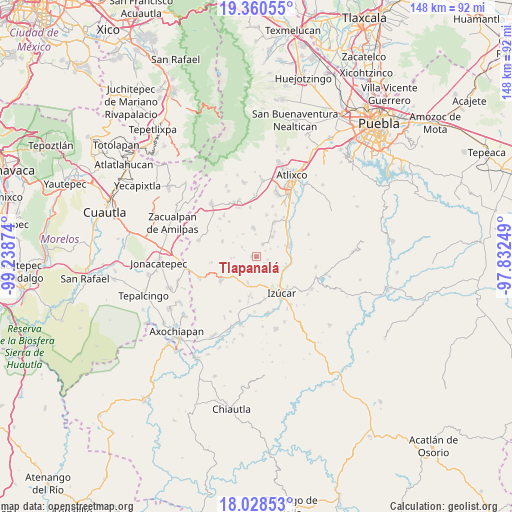
Tlapanalá GPS coordinates[2]
18° 41' 45.06" North, 98° 32' 8.196" West
| Map corner | latitude | longitude |
|---|---|---|
| Upper-left | 19.36055°, | -99.23874° |
| Center: | 18.69585°, | -98.53561° |
| Lower-right: | 18.02853°, | -97.83249° |
| Map W x H: | 148.1×148.1 km | = 92×92mi |
| max Lat: | 32.7° ⇑70.3% North |
| Tlapanalá: | 18.69585° |
| min Lat: | ⇓29.7% South 14.53588° |
| min Long | Tlapanalá | max Long |
| -117.105° | -98.53561° | -86.73105° |
| W 56.8%⇐ | ⇒43.2% E |
Elevation
Elevation of Tlapanalá is 1414 m = 4639 ft, and this is 160.3 m = 526 ft above average elevation for this country.
| Max E: |
3497 m = 11473 ft | 50.3% |
| Tlapanalá | 1414 m 4639 ft | |
| Avg. | 1253.7 m = 4113 ft | |
Min E: |
-1 m = -3 ft | 49.7% |
See also: Mexico elevation on elevation.city.
Geographical zone
Tlapanalá is located in North Torrid zone (between Equator and Tropic of Cancer). Distance of this Northern Tropic circle is 527.1 km =327.5 mi to North.| Distance of | km | miles | from Tlapanalá |
|---|---|---|---|
| North Pole | 7928.3 | 4926.4 | to North |
| Arctic Circle | 5322.4 | 3307.2 | to North |
| Tropic Cancer | 527.1 | 327.5 | to North |
| Equator | 2078.8 | 1291.7 | to South |


Nearby cities:
15 places around Tlapanalá: (largest is in red/bold)
• Agua Dulce
8.9 km =5.5 mi,  163°
163°
• Coatepec
4.1 km =2.5 mi,  219°
219°
• Colonia las Palmas
1.5 km =0.9 mi,  272°
272°
• Cuexpala
8 km =5 mi,  197°
197°
• Huaquechula
8.4 km =5.2 mi,  353°
353°
• La Galarza
9 km =5.6 mi,  110°
110°
• San Diego el Organal
4.4 km =2.7 mi,  27°
27°
• San Félix Rijo
8.5 km =5.3 mi,  190°
190°
• San Juan Vallarta
5.5 km =3.4 mi,  41°
41°
• Santiago Tetla
6.4 km =4 mi,  359°
359°
• Santo Domingo Ayotlicha
5.1 km =3.2 mi,  302°
302°
• Soto y Gama
9.1 km =5.7 mi, 36°
• Tepapayeca
2.9 km =1.8 mi,  167°
167°
• Tezonteopan de Bonilla
7.4 km =4.6 mi, 38°
• Tlapetlahuaya
7.6 km =4.7 mi,  330°
330°
Sources, notices
• [Note1] Compared only with cities in Mexico existing in our database
• [Src1] Map data: © OpenStreetMap contributors (CC-BY-SA)
• [Src2] Other city data from geonames.org with taken over terms of usage.
• [Src3] Geographical zone / Annual Mean Temperature by Robert A. Rohde @ Wikipedia
