Tlancualpican geodata
Tlancualpican (Puebla) is a populated place; located in Mexico in America/Mexico_City (GMT-6) time zone. With population of 4,024 people, there are 2263 cities with bigger population in this country. Compared to other cities in Mexico, 73.3% of cities are located further ↑North; 55.1% of cities are located further ←West and 60.2% of cities have higher elevation than Tlancualpican. Note1


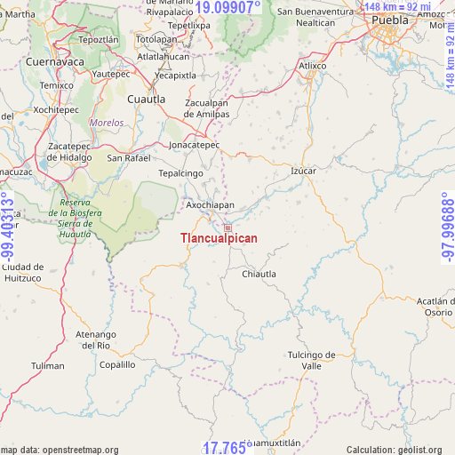
Tlancualpican GPS coordinates[2]
18° 25' 59.988" North, 98° 42' 0" West
| Map corner | latitude | longitude |
|---|---|---|
| Upper-left | 19.09907°, | -99.40313° |
| Center: | 18.43333°, | -98.7° |
| Lower-right: | 17.765°, | -97.99688° |
| Map W x H: | 148.3×148.3 km | = 92.1×92.1mi |
| max Lat: | 32.7° ⇑73.3% North |
| Tlancualpican: | 18.43333° |
| min Lat: | ⇓26.7% South 14.53588° |
| min Long | Tlancualpican | max Long |
| -117.105° | -98.7° | -86.73105° |
| W 55.1%⇐ | ⇒44.9% E |
Elevation
Elevation of Tlancualpican is 987 m = 3238 ft, and this is 266.7 m = 875 ft below average elevation for this country.
| Max E: |
3497 m = 11473 ft | 60.2% |
| Avg. | 1253.7 m = 4113 ft | |
| Tlancualpican | 987 m = 3238 ft | |
Min E: |
-1 m = -3 ft | 39.8% |
See also: Mexico elevation on elevation.city.
Geographical zone
Tlancualpican is located in North Torrid zone (between Equator and Tropic of Cancer). Distance of this Northern Tropic circle is 556.3 km =345.7 mi to North.| Distance of | km | miles | from Tlancualpican |
|---|---|---|---|
| North Pole | 7957.5 | 4944.6 | to North |
| Arctic Circle | 5351.6 | 3325.3 | to North |
| Tropic Cancer | 556.3 | 345.7 | to North |
| Equator | 2049.6 | 1273.6 | to South |


Nearby cities:
15 places around Tlancualpican: (largest is in red/bold)
• Ahuehuetzingo
9 km =5.6 mi,  48°
48°
• Atencingo
13.4 km =8.3 mi, 48°
• Atlacahualoya
12.3 km =7.6 mi,  345°
345°
• Axochiapan
9.5 km =5.9 mi,  323°
323°
• Buenavista de Benito Juárez
7.3 km =4.5 mi,  65°
65°
• Don Roque
9.2 km =5.7 mi,  56°
56°
• Huehuetlan el Chico
6.7 km =4.2 mi,  171°
171°
• Lagunillas de Rayón (Alchichica)
5.8 km =3.6 mi,  2°
2°
• Quebrantadero
13.9 km =8.6 mi, 316°
• San Miguel Tecolacio
3.6 km =2.2 mi, 74°
• San Nicolás Tenexcalco
12.2 km =7.6 mi, 64°
• Santa Ana Tecolapa
7.4 km =4.6 mi,  135°
135°
• Teotlalco
9.2 km =5.7 mi,  295°
295°
• Tlalayo
7.9 km =4.9 mi,  355°
355°
• Tzicatlán
6.2 km =3.9 mi,  288°
288°
Sources, notices
• [Note1] Compared only with cities in Mexico existing in our database
• [Src1] Map data: © OpenStreetMap contributors (CC-BY-SA)
• [Src2] Other city data from geonames.org with taken over terms of usage.
• [Src3] Geographical zone / Annual Mean Temperature by Robert A. Rohde @ Wikipedia
