San Miguel Tecolacio geodata
San Miguel Tecolacio (Puebla) is a populated place; located in Mexico in America/Mexico_City (GMT-6) time zone. With population of 657 people, there are 13209 cities with bigger population in this country. Compared to other cities in Mexico, 73.2% of cities are located further ↑North; 55.4% of cities are located further ←West and 59.7% of cities have higher elevation than San Miguel Tecolacio. Note1
Current local time in San Miguel Tecolacio:
06:48 AM, WednesdayDifference from your time zone: hours


San Miguel Tecolacio GPS coordinates[2]
18° 26' 30.984" North, 98° 40' 3" West
| Map corner | latitude | longitude |
|---|---|---|
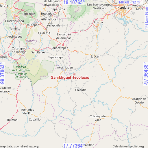
| Upper-left | 19.10765°, | -99.37063° |
| Center: | 18.44194°, | -98.6675° |
| Lower-right: | 17.77364°, | -97.96438° |
| Map W x H: | 148.3×148.3 km | = 92.1×92.1mi |
| max Lat: | 32.7° ⇑73.2% North |
| San Miguel Tecolacio: | 18.44194° |
| min Lat: | ⇓26.8% South 14.53588° |
| min Long | San Miguel Teco | max Long |
| -117.105° | -98.6675° | -86.73105° |
| W 55.4%⇐ | ⇒44.6% E |
Elevation
Elevation of San Miguel Tecolacio is 1018 m = 3340 ft, and this is 235.7 m = 773 ft below average elevation for this country.
| Max E: |
3497 m = 11473 ft | 59.7% |
| Avg. | 1253.7 m = 4113 ft | |
| San Miguel Tecolacio | 1018 m = 3340 ft | |
Min E: |
-1 m = -3 ft | 40.3% |
See also: Mexico elevation on elevation.city.
Geographical zone
San Miguel Tecolacio is located in North Torrid zone (between Equator and Tropic of Cancer). Distance of this Northern Tropic circle is 555.4 km =345.1 mi to North.| Distance of | km | miles | from San Miguel Tecolacio |
|---|---|---|---|
| North Pole | 7956.5 | 4943.9 | to North |
| Arctic Circle | 5350.6 | 3324.7 | to North |
| Tropic Cancer | 555.4 | 345.1 | to North |
| Equator | 2050.6 | 1274.2 | to South |


Nearby cities:
15 places around San Miguel Tecolacio: (largest is in red/bold)
• Ahuehuetzingo
6 km =3.7 mi,  34°
34°
• Atencingo
10.3 km =6.4 mi,  39°
39°
• Axochiapan
11.3 km =7 mi,  306°
306°
• Buenavista de Benito Juárez
3.8 km =2.4 mi,  57°
57°
• Don Roque
5.9 km =3.7 mi,  45°
45°
• Huehuetlan el Chico
8 km =5 mi,  197°
197°
• Lagunillas de Rayón (Alchichica)
5.8 km =3.6 mi,  326°
326°
• San Isidro el Organal
11.6 km =7.2 mi,  24°
24°
• San Nicolás Tenexcalco
8.7 km =5.4 mi, 59°
• Santa Ana Tecolapa
6.5 km =4 mi,  163°
163°
• Teotlalco
12.1 km =7.5 mi,  284°
284°
• Tlalayo
8 km =5 mi, 329°
• Tlancualpican
3.6 km =2.2 mi,  254°
254°
• Tzicatlán
9.4 km =5.8 mi, 275°
• Viborillas de Hidalgo
11.3 km =7 mi, 60°
Sources, notices
• [Note1] Compared only with cities in Mexico existing in our database
• [Src1] Map data: © OpenStreetMap contributors (CC-BY-SA)
• [Src2] Other city data from geonames.org with taken over terms of usage.
• [Src3] Geographical zone / Annual Mean Temperature by Robert A. Rohde @ Wikipedia
