Huehuetlan el Chico geodata
Huehuetlan el Chico (Puebla) is a seat of a second-order administrative division; located in Mexico in America/Mexico_City (GMT-6) time zone. With population of 4,742 people, there are 1948 cities with bigger population in this country. Compared to other cities in Mexico, 74.1% of cities are located further ↑North; 55.2% of cities are located further ←West and 60.6% of cities have higher elevation than Huehuetlan el Chico. Note1


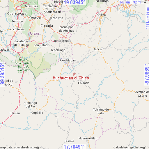
Huehuetlan el Chico GPS coordinates[2]
18° 22' 24.492" North, 98° 41' 24.072" West
| Map corner | latitude | longitude |
|---|---|---|
| Upper-left | 19.03945°, | -99.39315° |
| Center: | 18.37347°, | -98.69002° |
| Lower-right: | 17.70491°, | -97.9869° |
| Map W x H: | 148.4×148.4 km | = 92.2×92.2mi |
| max Lat: | 32.7° ⇑74.1% North |
| Huehuetlan el Chico: | 18.37347° |
| min Lat: | ⇓25.9% South 14.53588° |
| min Long | Huehuetlan el C | max Long |
| -117.105° | -98.69002° | -86.73105° |
| W 55.2%⇐ | ⇒44.8% E |
Elevation
Elevation of Huehuetlan el Chico is 964 m = 3163 ft, and this is 289.7 m = 950 ft below average elevation for this country.
| Max E: |
3497 m = 11473 ft | 60.6% |
| Avg. | 1253.7 m = 4113 ft | |
| Huehuetlan el Chico | 964 m = 3163 ft | |
Min E: |
-1 m = -3 ft | 39.4% |
See also: Mexico elevation on elevation.city.
Geographical zone
Huehuetlan el Chico is located in North Torrid zone (between Equator and Tropic of Cancer). Distance of this Northern Tropic circle is 563 km =349.8 mi to North.| Distance of | km | miles | from Huehuetlan el Chico |
|---|---|---|---|
| North Pole | 7964.1 | 4948.7 | to North |
| Arctic Circle | 5358.2 | 3329.4 | to North |
| Tropic Cancer | 563 | 349.8 | to North |
| Equator | 2042.9 | 1269.4 | to South |


Nearby cities:
15 places around Huehuetlan el Chico: (largest is in red/bold)
• Ahuehuetzingo
13.8 km =8.6 mi,  24°
24°
• Ayoxuxtla
13.8 km =8.6 mi,  212°
212°
• Buenavista de Benito Juárez
11.1 km =6.9 mi,  29°
29°
• Chiautla de Tapia
12.2 km =7.6 mi,  131°
131°
• Ciudad de Chiautla de Tapia
12.2 km =7.6 mi, 131°
• Don Roque
13.5 km =8.4 mi, 29°
• Lagunillas de Rayón (Alchichica)
12.5 km =7.8 mi,  356°
356°
• Pilcaya (San Juan Pilcaya)
15.3 km =9.5 mi,  186°
186°
• San Miguel Tecolacio
8 km =5 mi, 17°
• San Nicolás Tenexcalco
15.5 km =9.6 mi,  39°
39°
• Santa Ana Tecolapa
4.4 km =2.7 mi,  71°
71°
• Teotlalco
14.1 km =8.8 mi,  318°
318°
• Tlalayo
14.6 km =9.1 mi,  353°
353°
• Tlancualpican
6.7 km =4.2 mi, 351°
• Tzicatlán
11 km =6.8 mi, 321°
Sources, notices
• [Note1] Compared only with cities in Mexico existing in our database
• [Src1] Map data: © OpenStreetMap contributors (CC-BY-SA)
• [Src2] Other city data from geonames.org with taken over terms of usage.
• [Src3] Geographical zone / Annual Mean Temperature by Robert A. Rohde @ Wikipedia
